|
|

Lyons Avenue/Dockweiler Drive Extension Project
Draft Environmental Impact Report
Prepared for: City of Santa Clarita | 23920 Valencia Blvd., Ste. 302, Santa Clarita, CA 91355
Prepared by: Parker Environmental Consultants | August 16, 2017.
|
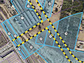
1. EXECUTIVE SUMMARY A. INTRODUCTION (a) Purpose of the EIR The purpose of this Draft Environmental Impact Report (Draft EIR) is to inform decision makers and the general public of the potential environmental impacts resulting from the proposed Dockweiler Drive Alignment Project ("Proposed Project"). The Proposed Project will require approval of certain discretionary actions by the City of Santa Clarita, and therefore, is subject to environmental review requirements under the California Environmental Quality Act (CEQA). For purposes of complying with CEQA, the City of Santa Clarita, located at 23920 Valencia Boulevard, CA 91355 is identified as the Lead Agency for the Proposed Project. As described in Section 15121(a) and 15362 of the CEQA Guidelines, an environmental impact report is an informational document which will inform public agency decision-makers and the public of the significant environmental effects of a project, identify possible ways to mitigate any significant environmental effects, and identify and evaluate a reasonable range of alternatives to the project that have the potential to mitigate or avoid the project's potential significant environmental effects while feasibly accomplishing most of the project's basic purposes. Therefore, the intent of this Draft EIR is to focus the discussion on the Proposed Project's potential physical effects on the environment, which may be significant under the methodology and thresholds of significance identified within each Section of this Draft EIR. Where applicable, the Draft EIR recommends feasible mitigation measures that could potentially reduce or avoid significant environmental impacts. This Draft EIR was prepared in accordance with Section 15151 of the CEQA Guidelines, which defines the standards for adequacy of an environmental impact report as follows: An EIR should be prepared with a sufficient degree of analysis to provide decision makers with information which enables them to make a decision which intelligently takes account of environmental consequences. An evaluation of the environmental effects of a Project need not be exhaustive, but the sufficiency of an EIR is to be reviewed in the light of what is reasonably feasible. Disagreement among experts does not make an EIR inadequate, but the EIR should summarize the main points of disagreement among the experts. The courts have looked not for perfection but for adequacy, completeness, and a good faith effort at full disclosure. (b) Overview of the Proposed Project Project Location The Project Site is located in the City of Santa Clarita, California located about 35 miles north of Downtown Los Angeles. The Project Site is located at the intersection of Lyons Avenue and Railroad Avenue and extends eastward towards the General Plan alignment for Dockweiler Drive towards The Master's University and northwest towards the intersection of 12th Street and Arch Street. The Project Site also includes the closure of an at-grade crossing at the intersection of Railroad Avenue and 13th Street. The limits for the Lyons Avenue/Dockweiler Drive extension ("Project Site") are from Railroad Avenue on the west to the future Master's University Master Plan Dockweiler extension to the east. Overview of the Environmental Setting The Project Site is currently zoned for MXN (Mixed Use Neighborhood). The portion of the Project Site that crosses the UP/Metrolink Railroad line is zoned for PI (Public Institutional). The General Plan land use designation of the Project Site is Mixed Use Neighborhood (MXN). The General Plan states that areas with a MXN designation should be developed to create neighborhoods that combine residential uses with complementary commercial services, including retail and office uses. MXN zoned areas should be located in close proximity to public transit and provide roadway and trail linkages to adjacent development. The PI zoning designation identifies lands that are used for various types of public or/and community serving facilities owned and operated by public agencies, special districts, nonprofit organizations and other entities. Allowable uses include civic and governmental offices, public works yards, public or private schools, libraries, day care centers, airports, hospitals and supporting medical facilities, museums, fire stations, police stations, landfills, and prisons. The Project Site is also located in the Placerita Canyon Special Standards District (PCSSD) and is part of the North Newhall Area (NNA), which includes a Mixed Use Overlay Zone. Overview of the Proposed Project The Proposed Dockweiler Drive Alignment Project is a multi-phased capital improvement project being coordinated by the City of Santa Clarita and The Master's University to improve circulation and access to the Placerita Canyon and Newhall Communities. The proposed connection and extension of Lyons Avenue to Dockweiler Drive is identified in the Circulation Element of the City's General Plan as one of the primary east-west arterials through the City of Santa Clarita that would provide a through connection from Sierra Highway to Railroad Avenue. The Proposed Project would extend Lyons Avenue from its existing terminus at Railroad Avenue, eastward to Dockweiler Drive to provide a T-intersection, and would extend northwest to connect with the intersection of Arch Street and 12th Street and southeast towards the General Plan alignment for Dockweiler Drive at The Master's University. The Proposed Project also includes the closure of an at-grade railroad crossing at the intersection of 13th Street and Railroad Avenue and the addition of a new at-grade railroad crossing at the intersection of Railroad Avenue and the proposed Lyons Avenue intersection. The Lyons Avenue/Dockweiler Drive extension would extend to the approved alignment of Dockweiler Drive at The Master's University campus. In coordination with the proposed Railroad Bike Path project, the new Dockweiler Drive extension will result in creating a vital Complete Street link between the communities to the east of the railroad/ Newhall Creek (including The Master's University) and Old Town Newhall and Metrolink station. A detailed description of the Proposed Project including specific street improvements is presented in Section 2.0 Proposed Project. B. ENVIRONMENTAL REVIEW PROCESS (a) Notice of Preparation/Scoping Meeting In compliance with Section 15082 of the CEQA Guidelines, a Notice of Preparation (NOP) was prepared by the City of Santa Clarita and distributed to the State Clearinghouse, Office of Planning and Research, responsible agencies, and other interested parties on August 5, 2013. The NOP and Notice of a Public Scoping Meeting was circulated for public review and comments for a 30-day period beginning on August 5, 2013 and ending on September 3, 2013. Appendix A to this Draft EIR contains a copy of the NOP and written responses to the NOP, respectively. The public scoping meeting was held on August 21, 2013, to obtain the public's initial views about environmental issues that should be evaluated in the Draft EIR in connection with the Proposed Project. City staff and representative technical consultants involved in the preparation of the EIR attended the scoping meeting. Comment letters were received by the following governmental agencies and organizations: (1) State of California, Governor's Office of Planning and Research (OPR), (2) California Native American Heritage Commission, (3) California Department of Fish and Wildlife; (4) California Public Utilities Commission (5) County of Los Angeles Chief Executive Office; (6) Los Angeles County Metropolitan Transportation Authority (Metro); (7) Southern California Gas Company, (8) the Southern California Regional Rail Authority (Metrolink). In addition to the responding governmental agencies, approximately 47 individuals provided written comments on the NOP. Appendix A to this Draft EIR contains the written comments provided to the City during the public scoping meeting, and the names of those in attendance at the scoping meeting who signed in requesting to be kept informed of the Project. (b) Environmental Issues Analyzed in the Draft EIR Based on a review of environmental issues by the City, the Initial Study, the responses to the NOP, and the input received at the public scoping meeting, this Draft EIR analyzes the following environmental issues:
A summary of the Proposed Project's environmental impacts, mitigation measures, and level of impact after mitigation is presented in Table 1-1, Summary of Environmental Impacts and Mitigation Measures, beginning on page 1-7. (c) Alternatives to the Proposed Project In compliance with Public Resources Code Section 21100 (4), and Sections 15121, 15126, and 15126.6 of the State CEQA Guidelines, the EIR evaluated a reasonable range of Project Alternatives. As discussed in greater detail in Section 6.0, Alternatives to the Project, the range of alternatives selected was based on the ability to feasibly attain most of the basic objectives of the proposed Project and the alternatives ability to avoid or substantially lessen any of the significant effects of the proposed Project. The Alternative Analysis includes the evaluation of a No Project Alternative (as mandated by CEQA), and two alternative alignments: Alignment Alternative 1 and Alignment Alternative 2. Alignment Alternative 1 would include the proposed roadway alignment and associated infrastructure of a new at-grade crossing at Lyons Avenue and Railroad Avenue and a secondary east-west arterial roadway connecting Lyons Avenue to the approved alignment of Dockweiler Drive at the Master's University Campus that would connect Dockweiler Drive to a new five-leg intersection at the Arch Street/12th Street/Placerita Canyon intersection. This alignment is similar to the Proposed Project except that the 13th Street at-grade crossing would remain operational under this alternative as opposed to being closed. Alignment Alternative 2 would involve the development of the proposed roadway alignment and associated infrastructure for Dockweiler Drive, as proposed, connecting Dockweiler Drive from the approved alignment at the Master's University Campus to the Arch Street/12th Street/Placerita Canyon intersection, but without the construction of a new at-grade crossing and connection from Lyons Avenue at Railroad Avenue. As evaluated in Section 6.5, Environmentally Superior Alternative, Alternative 2 was identified as the environmentally superior alternative as it would feasibly attain most of the basic objectives of the proposed Project to provide an additional connection from the Old Town Newhall community to Dockweiler Drive as contemplated under the Circulation Element of the General Plan, and although it would not reduce or eliminate the proposed Project's significant and unavoidable short-term localized construction air quality and construction noise impacts, it would reduce impacts associated with air quality, biological resources, cultural resources, geology/soils, hydrology, construction noise, aesthetics and traffic. Specifically, Alternative 2 would retain the existing aesthetic conditions and views at the Lyons Avenue and Railroad Avenue intersection, would avoid ground disturbance within Newhall Creek, and would reduce the total combined number of railroad crossing events at 13th Street, Market Street, Newhall Avenue and Lyons Avenue. The total average daily traffic railroad crossings is anticipated to be lowest under the Alternative 2 alignment for both the 2019 and 2035 buildout years. In 2019, Alternative 2 would result in 820 fewer crossings than the proposed Project and 3,160 fewer crossings than Alternative 1. For Year 2035, the total average daily traffic railroad crossings under Alternative 2 would result in 6,230 fewer crossings than the proposed Project and 8,740 fewer crossings as compared to Alternative 1. As such the Alternative 2 alignment would minimize railroad crossing events and would therefore be environmentally superior to the proposed Project. (d) Environmental Review Process The Draft EIR will be circulated for review and comment by the public and other interested parties, agencies, and organizations for a period of 60 days. After completion of the 60 day review period, a Final EIR will be prepared that responds to comments on the Draft EIR submitted during the review period and modifies the Draft EIR as required. Public hearings on the proposed Project will be held after completion of the Final EIR. The City will make the Final EIR available to agencies and the public prior to considering certification of the Final EIR. Notice of the time and location will be published prior to the public hearing date. All comments or questions about the Draft EIR should be addressed to: City of Santa Clarita Carla Callahan, Senior Engineer 23920 Valencia Boulevard, Suite 300 Santa Clarita, CA 91355 Fax: (661) 286-4130 Email: ccallahan@santa-clarita.com (e) Organization of the Draft EIR The Draft EIR is organized into eight sections as follows: Section 1 (Executive Summary): This section provides an introduction to the environmental review process and a summary of the proposed Project description, alternatives, environmental impacts, and mitigation measures. Section 2 (Project Description): A complete description of the proposed Project including Project location, Project Site characteristics, Project characteristics, Project objectives, and required discretionary actions is presented. Section 3 (Environmental Setting): An overview of the environmental setting of the proposed Project is provided including a description of existing and surrounding land uses, and a list of related projects. Section 4 (Environmental Impact Analysis): The Environmental Impact Analysis section is the primary focus of this Draft EIR. Separate discussions are provided to address the potential environmental effects of the proposed Project. Each environmental issue contains a discussion of existing conditions, an assessment and discussion of the significance of impacts associated with the proposed Project, mitigation measures, cumulative impacts, and level of impact significance after mitigation. Section 5 (General Impact Categories): This section provides a summary of significant and unavoidable impacts of the proposed Project, a summary of the impacts determined to be less than significant, a discussion of potential growth inducing effects, and an explanation of the significant irreversible environmental changes. Section 6 (Alternatives to the Project): This section includes an analysis of a range of reasonable alternatives to the proposed Project. The Alternative Analysis includes the following development scenarios: (a) No Project Alternative; (b) Alignment Alternative 1; (c) Alignment Alternative 2; and (d) an Environmentally Superior Alternative. Section 7 (Preparers of the Draft EIR and Persons Consulted): This section presents a list of lead agency and consultant team members that contributed to the preparation of the Draft EIR. Section 8 (Acronyms and Abbreviations): This section provides definitions for all of the acronyms and abbreviations used in this Draft EIR.
|
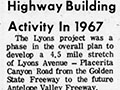
1967-2010
Lyons Oak/Stump
Draft EIR 8-16-2017
|

The site owner makes no assertions as to ownership of any original copyrights to digitized images. However, these images are intended for Personal or Research use only. Any other kind of use, including but not limited to commercial or scholarly publication in any medium or format, public exhibition, or use online or in a web site, may be subject to additional restrictions including but not limited to the copyrights held by parties other than the site owner. USERS ARE SOLELY RESPONSIBLE for determining the existence of such rights and for obtaining any permissions and/or paying associated fees necessary for the proposed use.
