Newhall residents are still waiting for Lyons Avenue to extend across the train tracks and hook up with Placerita Canyon Road, as promised in 1965
when the Board of Supervisors amended the
North Los Angeles County General Plan to include the "new town" of Valencia. Lyons-Placerita was envisioned as a southerly cross-valley connector, of sorts,
linking the new 5 and 14 Freeways.
That's not to say most folks liked the idea, as originally planned — or even knew about it at first.
1967 saw the first homes open in Valencia off of Lyons Avenue. To accomodate the added traffic, Lyons
was widened that year into a four-lane secondary highway from Interstate 5 to Valley Street/Orchard Village Road.
As The Signal reported at the time, the road widening project was part of an "overall plan to
develop a 4.5-mile stretch of Lyons Avenue-Placerita Canyon Road from the Golden State
Freeway to the future Antelope Valley Freeway."
By 1971, the county was ready to widen Lyons the rest of the way from Valley/Orchard Village eastward across the train
tracks, and by 1972 it had purchased all of the land it needed, including the site of the old Bamboo Cafe
at Lyons and Spruce streets and a road bed east of the tracks.
But there was a hitch. Actually a few hitches.
Any new railroad crossing requires approval from the California Public Utilities Commission.
Initially there was question as to whether the PUC, in approving a Lyons crossing, would require closure of the existing 13th Street and Market Street crossings
and require a grade separation at Lyons (either a tunnel under or a bridge over the road).
Business owners
in the economically significant 13th Street area protested the potential closure of their crossing. Meanwhile, Placerita Canyon homeowners were getting wise to what was about to happen.
In January 1972 the PUC approved an at-grade crossing at Lyons without requiring closure of any
existing crossing, as long as the county agreed not to argue if the PUC later determined a grade separation at Lyons was necessary.

1974: Death knell tolls for the Lyons Oak at Arcadia Street. Click to enlarge.
|
By this time it was about more than just linking Lyons with Placerita. Development of Circle J in Saugus was on the drawing board.
Circle J would eventually become a neighborhood community of single-family homes, but in 1972, it was going to sprout
2,000 apartment units or condominiums. Lyons would cross the tracks and link up with Placerita on the south,
and with a new Circle J feeder road called Emberbrook on the north. Traffic emanating from Circle J and Bouquet Canyon
would bypass San Fernando Road (now called Railroad Avenue) and funnel down a four-lane Emberbrook-Placerita highway.
Inflamed Placerita Canyon homeowners literally hanged and buried
Supervisor Warren Dorn in effigy to protest the planned slaughter of 70 oak trees to widen their road.
Even the PUC backpedaled under stiff community opposition led by homeowners
and oak advocates Dorothy Riley and Sonja Remmen. The PUC canceled the approval, and the county removed Placerita from its list of
roads to be widened in the future.
The oaks in Placerita Canyon were spared, but one stately old oak tree would suffer a different fate. Lyons still needed to be widened eastward
from Orchard Village to the existing north-south arterial, San Fernando Road. Locals physically harnessed themselves to a majestic heritage oak that stood in the way of
the road scrapers at Lyons and Arcadia Street in the fall of 1974 in a valiant but fruitless effort to save it. Today the stump of the "Lyons Oak" can
be seen at the Placerita Canyon Nature Center.
Dial up the clock a decade to the early 1980s, and the Lyons extension to "Emberbrook"
was back in play. The Los Angeles Times identified Connie Worden-Roberts and Laurene Weste as leaders in the
successful fight to erase Emberbrook from the county's planning map — over the objections of a new contingent of Bouquet
Canyon residents who wanted the quicker route out of town.
1987 brought cityhood for Santa Clarita, and soon after, the redesignation of Placeirta Canyon Road
as a private street with a gate at the east end. No longer were Placerita Canyon homeowners under
threat of seeing their rural, equestrian lifestyle destroyed by a four-lane highway.

2018: Jim Owens, Dan Kott and Denny Truger of the Placerita Canyon Nature Center Associates keep the story of the Lyons
Oak alive — and the Lyons Stump in good shape — along the paved walkway at the Nature Center. Click to enlarge.
|
The Lyons extension remained on the books, but with a different purpose.
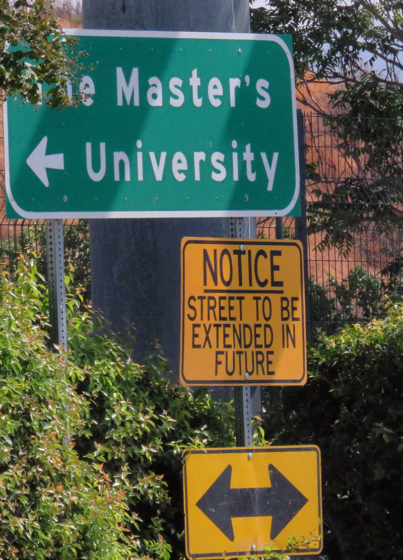
At the dawn of the 21st Century, Newhall redevelopment was underway, and The Master's College — a Placerita Canyon "resident" since 1961 — was growing
into The Master's University. The college made a significant investment in a master plan and new facilities
that depend on Dockweiler Drive — as an alternative to clogging Placerita with its expanding student body.
At that same time, a mixed-use development project called "North Newhall" was planned for
the open field east of Railroad Avenue between 13th Street and Circle J.
A Dockweiler Drive that stretched all the way from Sierra Highway to 13th Street would serve multiple needs without turning into a Bouquet Canyon/Circle J superhighway.
As before, PUC approval was required for a rail crossing at Lyons. In 2008 the PUC said "no" to an at-grade crossing,
and a grade separatation at that point was out of the question. The city and the would-be developer shelved the plans for North Newhall.
As of 2017-2018, Lyons and the train tracks will probably never meet, even though the city still owns the property it inherited from the county
east of the tracks. But the future of The Master's University and Dockweiler Drive remains to be written.
Update:
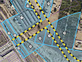
On April 10, 2018, the Santa Clarita City Council approved Alternative 2 of the Lyons Avenue/Dockweiler Drive EIR, which describes
a Dockweiler extension from its existing terminus near Valle del Oro on the south to
Arch Street on the north, with no Lyons extension and an improved at-grade crossing at 13th Street. The Dockweiler extension is outside the boundaries of the Placerita Canyon
Special Standards District except in the vicinity of Arch Street, where the plan contemplates a roundabout as shown below.
But first, PUC approval is required for the improvements to the 13th Street rail crossing.
Odds and Ends:
Note that Signal editor Scott Newhall called the Santa Clarita Valley "Valencia Valley" from the late 1960s to the early 1980s.
Historian A.B. Perkins, who says (below) he moved away from Lyons to get out of the way of the expansion, lived at 22941 Lyons Avenue, corner Kansas Street.
Perkins' house was one of the sections of the third Newhall School, which Perkins and a business partner bought in 1924 and
cut in half. Each man made his section to a private home, next door to one another (Perkins facing Lyons, the other facing Kansas). Perkins' home was razed for the Lyons expansion.
The other man's home was razed in 2014 for an apartment project.
A news article below suggests the under-construction Valencia Regional Library was to be named for Perkins. In fact, the main reading room was to be named for Perkins [see The Signal, January 22, 1969].

A roundabout is one possibility for managing traffic at the future junction of Dockweiler, Placerita, Arch and 12th streets. Click to enlarge.
|
Click to enlarge.
|
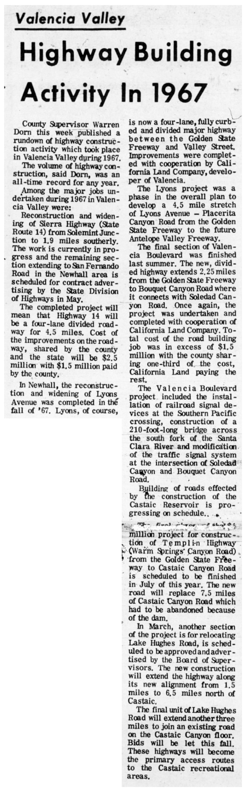
Highway Building Activity In 1967
The Signal | February 9, 1968.
County Supervisor Warren Dorn this week published a rundown of highway construction activity which took place in Valencia Valley during 1967.
The volume of highway construction, said Dorn, was an all-time record for any year.
Among the major jobs undertaken during 1967 in Valencia Valley were:
Reconstruction and widening of Sierra Highway (State Route 14) from Solemint Junction to 1.9 miles southerly. The work is currently in progress and the remaining section extending to San Fernando Road in the Newhall area is scheduled for contract advertising by the State Division of Highways in May.
The completed project will mean that Highway 14 will be a four-lane divided roadway for 4.5 miles. Cost of the improvements on the roadway, shared by the county and the state, will be $2.5 million with $1.5 million paid by the county.
In Newhall, the reconstruction and widening of Lyons Avenue was completed in the fall of '67. Lyons, of course, is now a four-lane, fully curbed and divided major highway between the Golden State Freeway and Valley Street. Improvements were completed with cooperation by California Land Company, developer of Valencia.
The Lyons project was a phase in the overall plan to develop a 4.5-mile stretch of Lyons Avenue-Placerita Canyon Road from the Golden State Freeway to the future Antelope Valley Freeway.
The final section of Valencia Boulevard was finished last summer. The new, divided highway extends 2.25 miles from the Golden State Freeway to Bouquet Canyon Road where it connects with Soledad Canyon Road. Once again, the project was undertaken and completed with cooperation of California Land Company. Total cost of the road building job was in excess of $1.5 million with the county sharing one-third of the cost, California Land paying the rest.
The Valencia Boulevard project included the installation of railroad signal devices at the Southern Pacific crossing, construction of a 210-foot-long bridge across the south fork of the Santa Clara River and modification of the traffic signal system at the intersection of Soledad Canyon and Bouquet Canyon Road.
Building of roads effected by the construction of the Castaic Reservoir is progressing on schedule.
The final phase of the [illegibile] million (dollar) project for construction of Templin Highway (Warm Springs Canyon Road) from the Golden State Freeway to Castaic Canyon Road is scheduled to be finished in July of this year. The new road will replace 7.5 miles of Castaic Canyon Road which had to be abandoned because of the dam.
In March, another section of the project is for relocating Lake Hughes Road, is scheduled to be approved and advertised by the Board of Supervisors. The new construction will extend the highway along its new alignment from 1.5 miles to 6.5 miles north of Castaic.
The final unit of Lake Hughes Road will extend another three miles to join an existing road on the Castaic Canyon floor. Bids will be let this fall. These highways will become the primary access routes to the Castaic recreational areas.
|
|
Click to enlarge.
|
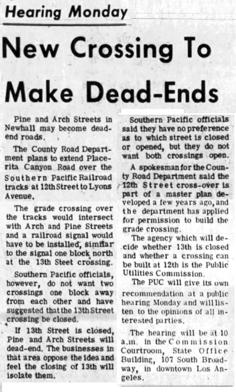
New Crossing to Make Dead-Ends
The Signal | April 16, 1971.
Pine and Arch Streets in Newhall may become dead-end roads.
The County Road Department plans to extend Placerita Canyon Road over the Southern Pacific Railroad tracks at 12th Street to Lyons Avenue.
The grade crossing over the tracks would intersect with Arch and Pine Streets and a railroad signal would have to be installed, similar to the signal one block north at the 13th Street crossing.
Southern Pacific officials, however, do not want two crossings one block away from each other and have suggested that the 13th Street crossing be closed.
If 13th Street is closed, Pine and Arch Streets will dead-end. The businesses in that area oppose the idea and feel the closing of 13th will isolate them.
Southern Pacific officials said they have no preference as to which street is closed or opened, but they do not want both crossings open.
A spokesman for the County Road Department said the 12th Street cross-over is part of a master plan developed a few years ago, and the department has applied for permission to build the grade crossing.
The agency which will decide whether 13th is closed, and whether a crossing can be built at 12th, is the Public Utilities Commission.
The PUC will give its own recommendation at a public hearing Monday and will listen to the opinions of all interested parties.
The hearing will be at 10 a.m. in the Commission Courtroom, State Office Building, 107 South Broadway, in downtown Los Angeles.
|
|

Click to enlarge.
|
Lyons Ave. Crossing Undecided
The Signal | April 23, 1971.
The fate of Arch Street between 12th and 13th Streets in Newhall is still unknown.
A hearing was held Monday by the Public Utilities Commission (PUC) on the proposed continuation of Lyons Avenue onto 12th Street across the Southern Pacific Railroad tracks.
The County Road Department has proposed continuing the street over the railroad tracks to join with Placerita Canyon Road. The proposal has been in the master plans of the Road Department for some time.
But Southern Pacific Railroad officials do not like the proposal, since it will mean another over-crossing at 12th Street, one block from the already existing over-crossing at 13th Street.
Southern Pacific would agree to a crossing at either 13th or 12th, but not both.
In addition, the business owners on Arch and Placerita, between 12th and 13th, do not want a dead-end street, which would happen if the 13th Street over-crossing is closed.
To settle the dispute, a hearing was scheduled by the PUC, but the issue was not resolved.
The PUC said that Southern Pacific did not petition to close the 13th Street over-crossing, and continued the hearing on the matter to an indefinite date.
There is also a question now about whether the Market Street over-crossing should be closed. The PUC has decided to wait until all requests and petitions have been filed before taking action.
|
|
Click to enlarge.
|
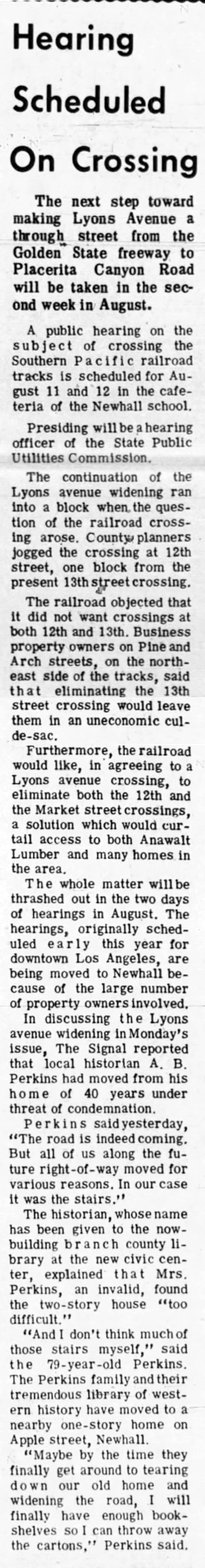
Hearing Scheduled on Crossing
The Signal | June 18, 1971.
The next step toward making Lyons Avenue a through street from the Golden State freeway to Placerita Canyon Road will be taken in the second week in August.
A public hearing on the subject of crossing the Southern Pacific railroad tracks is scheduled for August 11 and 12 in the cafeteria of the Newhall school.
Presiding will be a hearing officer of the State Public Utilities Commission.
The continuation of the Lyons avenue widening ran into a block when the question of the railroad crossing arose. County planners jogged the crossing at 12th street, one block from the present 13th street crossing.
The railroad objected that it did not want crossings at both 12th and 13th. Business property owners on Pine and Arch streets, on the northeast side of the tracks, said that eliminating the 13th street crossing would leave them in an uneconomic cul-de-sac.
Furthermore, the railroad would like, in agreeing to a Lyons avenue crossing, to eliminate both the 12th and the Market street crossings, a solution which would curtail access to both Anawalt Lumber and many homes in the area.
The whole matter will be thrashed out in the two days of hearings in August. The hearings, originally scheduled early this year for downtown Los Angeles, are being moved to Newhall because of the large number of property owners involved.
In discussing the Lyons avenue widening in Monday's issue, The Signal reported that local historian A.B. Perkins had moved from his home of 40 years under threat of condemnation.
Perkins said yesterday, "The road is indeed coming. But all of us along the future right-of-way moved for various reasons. In our case it was the stairs."
The historian, whose name has been given to the now-building branch county library at the new civic center, explained that Mrs. Perkins, an invalid, found the two-story house "too difficult."
"And I don't think much of those stairs myself," said the 79-year-old Perkins. The Perkins family and their tremendous library of western history have moved to a nearby one-story home on Apple street, Newhall.
"Maybe by the time they finally get around to tearing down our old home and widening the road, I will finally have enough bookshelves so I can throw away the cartons," Perkins said.
|
|

Click to enlarge.
|
The Signal | August 6, 1971.
Should Lyons avenue be continued across the Southern Pacific tracks to Placerita Canyon Road?
If so, should the 13th and Market street crossings be changed or eliminated?
These questions will be considered at public hearings to be held at 10 a.m. Tuesday in the cafeteria of the Newhall Elementary school, 24607 Walnut Street, Newhall.
The hearing will be conducted by the Public Utilities Commission.
The further widening of Lyons Avenue, from Orchard Village Road to San Fernando Road, has been awaiting a decision on the matter of a crossing.
Proponents of and objectors to the crossing have expressed strong views. Some objections come from owners of business property on Arch Street, whose frontage will become a dead end if the Lyons-12th street crossing is opened and 13th street is closed.
Placerita Canyon residents trying to forestall a major highway through their wooded area are also involved, since the crossing will open their street to heavier traffic.
In case many witnesses are to be heard, the hearing will continue on Wednesday.
|
|
Click to enlarge.
|
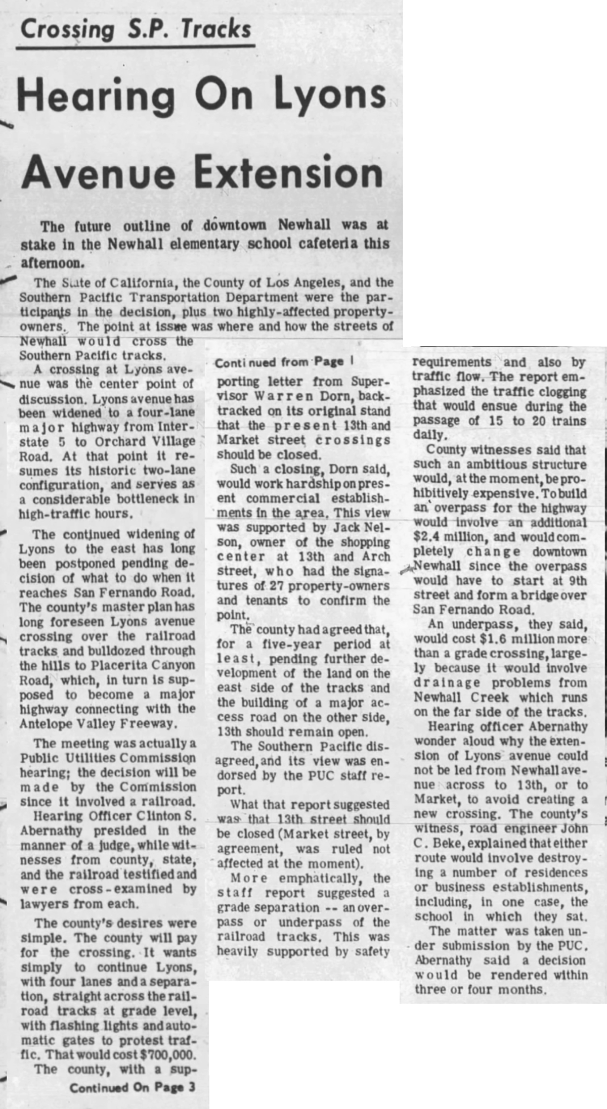
Hearing on Lyons Avenue Extension
The Signal | August 13, 1971.
The future outline of downtown Newhall was at stake in the Newhall elementary school cafeteria this afternoon.
The State of California, the County of Los Angeles, and the Southern Pacific Transportation Department were the participants in the decision, plus two highly affected property owners. The point at issue was where and how the streets of Newhall would cross the Southern Pacific tracks.
A crossing at Lyons avenue was the center point of discussion. Lyons avenue has been widened to a four-lane major highway from Interstate 5 to Orchard Village Road. At that point it resumes its historic two-lane configuration, and serves as a considerable bottleneck in high-traffic hours.
The continued widening of Lyons to the east has long been postponed pending decision of what to do when it reaches San Fernando Road. The county's master plan has long foreseen Lyons avenue crossing over the railroad tracks and bulldozed through the hills to Placerita Canyon Road, which, in turn is supposed to become a major highway connecting with the Antelope Valley Freeway.
The meeting was actually a Public Utilities Commission hearing; the decision will be made by the Commission since it involved a railroad.
Hearing Officer Clinton S. Abernathy presided in the manner of a judge, while witnesses from county, state, and the railroad testified and were cross-examined by lawyers from each.
The county's desires were simple. The county will pay for the crossing. It wants simply to continue Lyons, with four lanes and a separation, straight across the railroad tracks at grade level, with flashing lights and automatic gates to [protect] traffic. That would cost $700,000.
The county, with a supporting letter from Supervisor Warren Dorn, backtracked on its original stand that the present 13th and Market street crossings should be closed.
Such a closing, Dorn said, would work hardship on present commercial establishments in the area. This view was supported by Jack Nelson, owner of the shopping center at 13th and Arch street, who had the signatures of 27 property owners and tenants to confirm the point.
The county had agreed that, for a five-year period at least, pending further development of the land on the east side of the tracks and the building of a major access road on the other side, 13th should remain open.
The Southern Pacific disagreed, and its view was endorsed by the PUC staff report.
What that report suggested was that 13th street should be closed (Market street, by agreement, was ruled not affected at the moment).
More emphatically, the staff report suggested a grade separation — an overpass or underpass of the railroad tracks. This was heavily supported by safety requirements and also by traffic flow. The report emphasized the traffic clogging that would ensue during the passage of 15 to 20 trains dally.
County witnesses said that such an ambitious structure would, at the moment, be prohibitively expensive. To build an overpass for the highway would involve an additional $2.4 million, and would completely change downtown Newhall since the overpass would have to start at 9th street and form a bridge over San Fernando Road.
An underpass, they said, would cost $1.6 million more than a grade crossing, largely because it would involve drainage problems from Newhall Creek which runs on the far side of the tracks.
Hearing officer Abemathy wondered aloud why the extension of Lyons avenue could not be led from Newhall avenue across to 13th, or to Market, to avoid creating a new crossing. The county's witness, road engineer John C. Beke, explained that either route would involve destroying a number of residences or business establishments, including, in one case, the school in which they sat.
The matter was taken under submission by the PUC. Abernathy said a decision would be rendered within three or four months.
|
|
Click to enlarge.
|
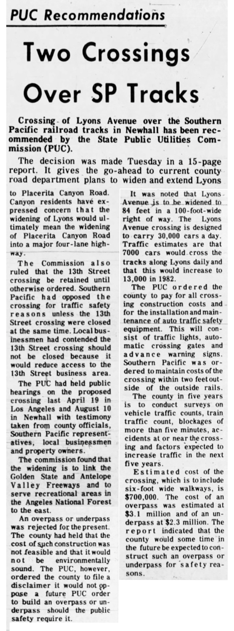
Two Crossings Over SP Tracks
The Signal | January 28, 1971.
Crossing of Lyons Avenue over the Southern Pacific railroad tracks in Newhall has been recommended by the State Public Utilities Commission (PUC).
The decision was made Tuesday in a 15-page report. It gives the go-ahead to current county road department plans to widen and extend Lyons to Placerita Canyon Road. Canyon residents have expressed concern that the widening of Lyons would ultimately mean the widening of Placerita Canyon Road into a major four-lane highway.
The Commission also ruled that the 13th Street crossing be retained until otherwise ordered. Southern Pacific had opposed the crossing for traffic safety reasons unless the 13th Street crossing were closed at the same time. Local businessmen had contended the 13th Street crossing should not be closed because it would reduce access to the 13th Street business area.
The PUC had held public hearings on the proposed crossing last April 19 in Los Angeles and August 10 in Newhall with testimony taken from county officials, Southern Pacific representatives, local businessmen and property owners.
The commission found that the widening is to link the Golden State and Antelope Valley Freeways and to serve recreational areas in the Angeles National Forest to the east.
An overpass or underpass was rejected for the present. The county had held that the cost of such construction was not feasible and that it would not be environmentally sound. The PUC, however, ordered the county to file a disclaimer it would not oppose a future PUC order to build an overpass or underpass should the public safety require it.
It was noted that Lyons Avenue is to be widened to 84 feet in a 100-foot-wide right of way. The Lyons Avenue crossing is designed to carry 30,000 cars a day Traffic estimates are that 7,000 cars would cross the tracks along Lyons daily and that this would increase to 13,000 in 1982.
The PUC ordered the county to pay for all crossing construction costs and for the installation and maintenance of auto traffic safety equipment. This will consist of traffic lights, automatic crossing gates and advance warning signs. Southern Pacific was ordered to maintain costs of the crossing within two feet outside of the outside rails.
The county in five years is to conduct surveys on vehicle traffic counts, train traffic count, blockages of more than five minutes, accidents at or near the crossing and factors expected to increase traffic in the next five years.
Estimated cost of the crossing, which is to include six-foot wide walkways, is $700,000. The cost of an overpass was estimated at $3.1 million and of an underpass at $2.3 million. The report indicated that the county would some time in the future be expected to construct such an overpass or underpass for safety reasons.
|
|

Click to enlarge.
|
Oaks Inviolate, Dorn Promises
The Signal | January 28, 1972.
County Supervisor Warren Dorn Wednesday met with Placenta Canyon residents to discuss the future of Placerita Canyon Road.
At the 4 p.m. meeting were about 30 residents and local civic leaders. Dorn had come in response to a request by canyon resident Ms. Beatrice Davis.
The residents have been concerned that Placerita Canyon Road would be widened to a four-lane highway in view of current road projects and development of the surrounding area. The widening they have feared would change the rustic flavor of the ranch-like homes and lots along the road.
The residents have cited the presence of the four-lane version of the oak-lined road on the master plan, the extension of Lyons Avenue east across the railroad tracks and the construction of four-lane Emberbrook Drive to connect with Lyons Avenue as all pointing to future widening of the road. Emberbrook Drive would be constructed as an access road for the proposed Circle J Ranch development north of Placerita Canyon, for which 2,000 condominium apartments are planned.
With Dorn in a classroom at the Nature Study Center off Placerita Canyon Road, was Norman Martindale, County Chief Deputy Road Commissioner.
Martindale displayed a road map of the projected routes. It showed a four-lane Lyons Avenue joining Emberbrook Drive, then continuing east and narrowing to two lanes before joining Placerita Canyon Road.
Dorn asked if any trees would be cut down if the displayed routing went through. "None whatsoever," said Martindale, then saying one dead oak west of Emberbrook would have to be removed. He added also that four young elm trees would have to be cut down near Lyons and Emberbrook, but said replacement trees could be planted.
To a question as to why Lyons had to be extended to Placerita Canyon Road, he said, not to do this would mean a circuitous trip of a quarter mile to get on or off the west end of the road, a situation which now exists with the 13th Street railroad crossing to Arch Street to the road.
As Dorn repeatedly asked if oaks would be cut down, Martindale said a stand of eight oaks along the transition route would be spared. He said also that the road would be so graded that driveways along Placerita Canyon Road would be at road level, another concern of residents. Residents' views would not be obstructed, he said. Dorn added, "Except by the trees."
Ms. Dorothy Riley, a spokesman for the homeowners, pointed to an earlier Supervisors' resolution ordering accelerated studies of alternate routes for a four-lane highway instead of Placerita Canyon Road. Dorn had earlier said the widening of Placerita Canyon could not be taken off the master plan until an alternate route had been chosen. He said Wednesday that he had "told them" to take the road off the master plan even without the alternative route.
One resident argued that it makes no sense to extend Lyons Avenue. She was told that the extension over the railroad tracks had to be approved by the State Public Utilities Commission and was out of county hands, though it was not made clear just who owns Lyons Avenue. (The county does.)
Dorn acknowledged there would be increased traffic along Placerita Canyon, but said it was a question of wanting the oaks or wanting something of a traffic hazard on the narrow winding road. He said he preferred to keep the oaks and use road safety devices to minimize the hazard. "I'd rather have the people drive slowly and enjoy the beautiful scenery we have."
Dorn was asked about the 100-foot-wide entrance to the road from Sierra Highway. He replied that that was a state jurisdiction, not the county's.
Martindale said. "Looking off in the future, we see no need for improvement" of the road. He added, however, residents seem unable to believe this. He added that traffic volume studies at present and projected do not indicate a need for widening of the road. He said Lyons Avenue had to be extended to tie the communities together. "We don't intend to widen that street," Dorn said, "you can be darn sure of that." Dorn had dropped the "damn" from his phrase of assurance which had been a source of amusement to his fellow Supervisors at the zone hearing on the Circle J Ranch January 20.
Canyon property owners had last October buried Dorn in effigy during the "save the oaks" controversy. And the oaks question came up at the Supervisors meeting which many canyon residents attended.
Ms. Davis after the meeting said she was still apprehensive about the road's future in the long run, though she said she was gratified by the interest Dorn had taken in the matter.
|
|
Click to enlarge.
|
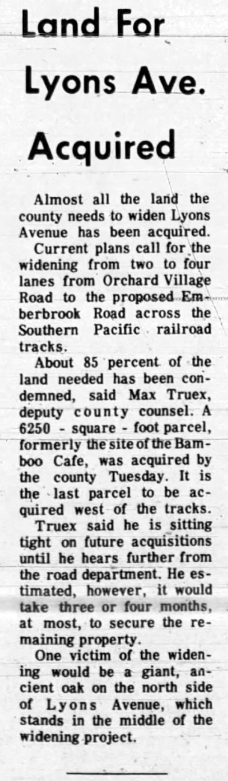
Land for Lyons Ave. Acquired
The Signal | January 28, 1972.
Almost all the land the county needs to widen Lyons Avenue has been acquired.
Current plans call for the widening from two to four lanes from Orchard Village Road to the proposed Emberbrook Road across the Southern Pacific railroad tracks.
About 85 percent of the land needed has been condemned, said Max Truex, deputy county counsel. A 6,250-square-foot parcel, formerly the site of the Bamboo Cafe, was acquired by the county Tuesday. It is the last parcel to be acquired west of the tracks.
Truex said he is sitting tight on future acquisitions until he hears further from the road department. He estimated, however, it would take three or four months, at most, to secure the remaining property.
One victim of the widening would be a giant, ancient oak on the north side of Lyons Avenue, which stands in the middle of the widening project.
|
|
Click to enlarge.
|
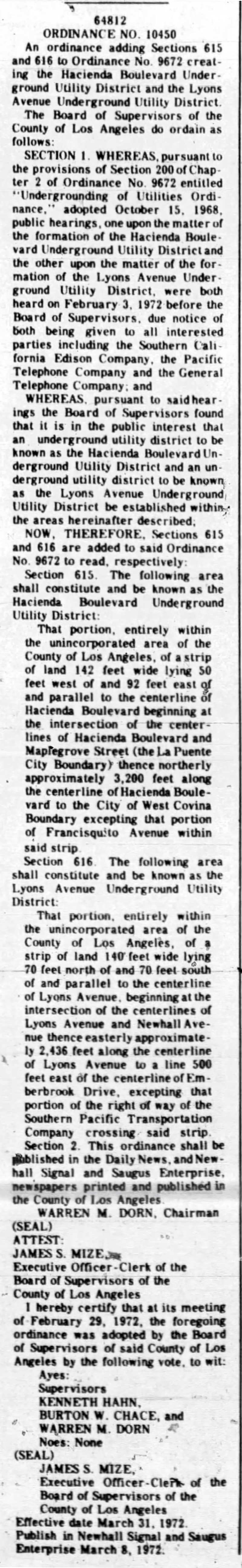
The Signal | March 8, 1972.
64812
ORDINANCE NO 10450
An ordinance adding Sections 615 and 616 to Ordinance No. 9672 creating the Hacienda Boulevard Underground Utility District and the Lyons Avenue Underground Utility District.
The Board of Supervisors of the County of Los Angeles do ordain as follows:
SECTION I. WHEREAS, pursuant to the provisions of Section 200 of Chapter 2 of Ordinance No 9672 entitled "Undergrounding of Utilities Ordinance,'' adopted October 15, 1968, public hearings, one upon the matter of the formation of the Hacienda Boulevard Underground Utility District and the other upon the matter of the formation of the Lyons Avenue Underground Utility District, were both heard on February 3, 1972 before the Board of Supervisors, due notice of both being given to all interested parties including the Southern California Edison Company, the Pacific Telephone Company and the General Telephone Company, and
WHEREAS, pursuant to said hearings the Board of Supervisors found that it is in the public interest that an underground utility district to be known as the Hacienda Boulevard Underground Utility District and an underground utility district to be known as the Lyons Avenue Underground Utility District be established within the areas hereinafter described.
NOW. THEREFORE. Sections 615 and 616 are added to said Ordinance No 9672 to read, respectively
[...]
Section 616. The following area shall constitute and be known as the Lyons Avenue Underground Utility District:
That portion, entirely within the unincorporated area of the County of Los Angeles, of a strip of land 140" feet wide lying 70 feel north of and 70 feet south of and parallel to the centerline of Lyons Avenue, beginning at the intersection of the centerlines of Lyons Avenue and Newhall Avenue thence easterly approximately 2,436 feet along the centerline of Lyons Avenue to a line 500 feet east of the centerline of Emberbrook Drive, excepting that portion of the right of way of the Southern Pacific Transportation Company crossing said strip.
Section 2. This ordinance shall be published in the Daily News, and Newhall Signal and Saugus Enterprise, newspapers printed and published in the County of Los Angeles.
WARREN MDORN, Chairman (SEAL)
ATTEST:
[...]
|
|
Click to enlarge.
|
The Signal | April 26, 1972.
The California Public Utilities Commission changed its mind this week about the Lyons Avenue overcrossing.
Commissioners in January had approved plans for Lyons Avenue to be extended across railroad tracks into Placerita Canyon.
A new hearing will be held by the PUC at a place and time yet to be announced.
Ms. Sonja Remmen, leader of Citizens United for a Respectable Environment, said the hearing will give "people an opportunity" to press for alternative plans. Protests arose over the planned grade separation across Southern Pacific's main north-south tracks because the crossing would have committed the County Road Department to a route down the center of the canyon, opponents of the proposal claimed. Opposition to the plans originally sprang from concern by CURE and the Placerita Canyon Property Owners Association over 70 oaks that would have been axed to make way for road expansion.
The decision in January bv the PUC stipulated the grade crossing eventually would be replaced by a permanent bridge overpass at the west end of Placerita Canyon. The grade separation and ultimately the bridge would have dumped busy east-west traffic into the rustic canyon.
Letters from Southern Pacific Railroad, the county and the homeowners group criticized — for different reasons — the January decision. The PUC on Tuesday rescinded its January judgment and ordered the new hearing.
Southern Pacific complained about a clause in the January decision which would have required it to keep the present 13th Street railroad crossing open along with the Lyons Avenue crossing.
Ronald L. Schneider, the Road Department's lawyer, contended in his complaint the PUC was illegally forcing the county to promise it would never complain from an environmental standpoint about a permanent overpass.
The homeowners insisted in a letter written by Ms. Dorothy Riley of 21224 Placerita Canyon Road that the January decision was made without sufficient consideration of the problems they faced.
|
|

Click to enlarge.
|
Newhall Residents Stall Highway Plan
Los Angeles Times | August 12, 1982.
Newhall residents and businessmen, angered over plans to construct a major access route to Bouquet Canyon through the scenic Placenta Canyon area, have temporarily blocked the proposal which had been scheduled for adoption today by Los Angeles County Supervisors.
Controversy over the proposal erupted two weeks ago when residents said they first learned of plans to build a highway into their rural, equestrian-oriented community.
After meeting with more than 150 angry Newhall residents Monday, county officials recommended that supervisors postpone action.
The proposal called for construction of a major four-lane highway from Emberbrook Drive at San Fernando Road near Circle J Ranch Road in Newhall. across Soledad Canyon Road to Bouquet Canyon Road near the intersection of Seco Canyon Road in Saugus.
Opponents charge that the route would infringe on hundreds of residential equestrian estates in the Placerita Canyon area of Newhall and destroy the rural life style of the community.
Jo Anne Darcy, field deputy for Supervisor Michael D. Antonovich, said the postponement will delay a decision on the route for at least six weeks.
Construction of the route was recommended by the Regional Highway Commission and the Santa Clarita Valley Planning Advisory Committee as the most feasible solution for alleviating traffic congestion along Bouquet Canyon Road and for allowing new development in the Saugus area.
Several routes have been under study for some time to designate an alternative access between the Bouquet Canyon area and cither Highway 14 or Interstate 5. Bouquet Canyon Road currently is the only route into the area and has severe traffic congestion where it intersects with San Fernando and Soledad Canyon roads and Valencia Boulevard.
A moratorium is in effect on new development in the area until an alternative access route is adopted. Both state and county officials maintain they lack funds for development of alternative routes and said the cost of a new road will have to be borne by assessments on new housing construction.
Lawrence V. Muto, assistant chief deputy road commissioner, said the proposed development of Emberbrook Drive into a major highway has been included in the county's plan for major highway development for more than 10 years. The current proposal calls for inclusion of the route in a new county master plan for highway development.
However, residents said they were unaware of the proposed highway until a public hearing on adoption of the route was scheduled before supervisors July 29. Another proposal to reroute and develop narrow, scenic Placerita Canyon Road between San Fernando Road and Sierra Highway was deleted from the county plan 10 years ago because of protests by residents.
Laurene Frimel Weste, secretary of the Newhall Civic Assn., said her organization, which represents Newhall businessmen and residents, has joined with homeowners in Placerita Canyon to block the Emberbrook proposal.
She said residents are conducting a petition drive requesting the county to conduct a study of alternative routes to serve the Bouquet Canyon area, including comparative environmental impacts, economic impacts and cost analysis studies.
"We don't believe the county has to devastate the lifestyle of one area to accommodate the growth of another," she said. Weste said residents are particularly concerned about alternatives under consideration by the county for financing construction of new highways, since tax funds are no longer available.
Representatives of the community will attend a 9 a.m. meeting Friday of the Regional Planning Commission, at which financing alternatives will be discussed. The meeting will be held in Room 150 at the Hall of Records, 320 W. Temple St., Los Angeles.
|
|
Click to enlarge.
|
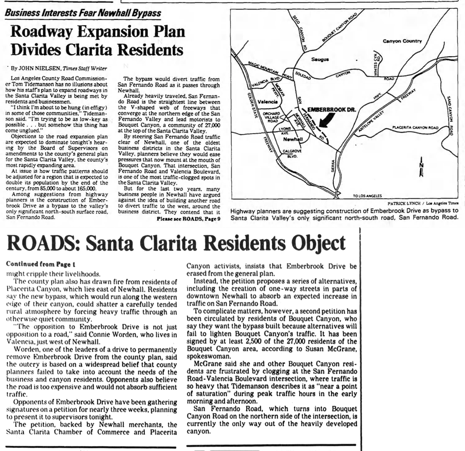
Business Interests Fear Newhall Bypass
Roadway Expansion Plan Divides Clarita Residents
Los Angeles Times | February 16, 1984.
Los Angeles County Road Commissioner Tom Tidemanson has no illusions about how his staff's plan to expand roadways in the Santa Clarita Valley is being met by residents and businessmen.
"I think I'm about to be hung (in effigy) in some of those communities," Tidemanson said. "I'm trying to be as low-key as possible ... but somehow this thing has come unglued."
Objections to the road expansion plan are expected to dominate tonight's hearing by the Board of Supervisors on amendments to the county's general plan for the Santa Clarita Valley, the county's most rapidly expanding area.
At issue is how traffic patterns should be adjusted for a region that is expected to double us population by the end of the century, from 85,000 to about 165,000.
Among suggestions from highway planners is the construction of Emberbrook Drive as a bypass to the valley's only significant north-south surface road, San Fernando Road.
The bypass would divert traffic from San Fernando Road as it passes through Newhall.
Already heavily traveled, San Fernando Road is the straightest line between the V-shaped web of freeways that converge at the northern edge of the San Fernando Valley and lead motorists to Bouquet Canyon, a community of 27,000 at the top of the Santa Clarita Valley.
By steering San Fernando Road traffic clear of Newhall, one of the oldest business districts in the Santa Clarita Valley, planners believe they would ease pressures that now mount at the mouth of Bouquet Canyon. That intersection, San Fernando Road and Valencia Boulevard, is one of the most traffic-clogged spots in the Santa Clarita Valley.
But for the last two years, many business people in Newhall have argued against the idea of building another road to divert traffic to the west, around the business district. They contend that it might cripple their livelihoods.
The county plan also has drawn fire from residents of Placerita Canyon, which lies east of Newhall. Residents say the new bypass, which would run along the western edge of their canyon, could shatter a carefully tended rural atmosphere by forcing heavy traffic through an otherwise quiet community.
"The opposition to Emberbrook Drive is not just opposition to a road," said Connie Worden, who lives in Valencia, just west of Newhall.
Worden, one of the leaders of a drive to permanently remove Emberbrook Drive from the county plan, said the outcry is based on a widespread belief that county planners failed to take into account the needs of the business and canyon residents. Opponents also believe the road is too expensive and would not absorb sufficient traffic.
Opponents of Emberbrook Drive have been gathering signatures on a petition for nearly three weeks, planning to present it to supervisors tonight.
The petition, backed by Newhall merchants, the Santa Clarita Chamber of Commerce and Placerita Canyon activists, insists that Emberbrook Drive be erased from the general plan.
Instead, the petition proposes a series of alternatives, including the creation of one-way streets in parts of downtown Newhall to absorb an expected increase in traffic on San Fernando Road.
To complicate matters, however, a second petition has been circulated by residents of Bouquet Canyon, who say they want the bypass built because alternatives will fail to lighten Bouquet Canyon's traffic. It has been signed by at least 2,500 of the 27,000 residents of the Bouquet Canyon area, according to Susan McGrane, spokeswoman.
McGrane said she and other Bouquet Canyon residents are frustrated by clogging at the San Fernando Road-Valencia Boulevard intersection, where traffic is so heavy that Tidemanson describes it as "near a point of saturation" during peak traffic hours in the early morning and afternoon.
San Fernando Road, which turns into Bouquet Canyon Road on the northern side of the intersection, is currently the only way out of the heavily developed canyon.
|
|

Click to enlarge.
|
Study Says Extension Would Ease Santa Clarita Traffic
Los Angeles Times | November 5, 1991.
A draft report on extending Lyons Avenue to the Antelope Valley Freeway in Santa Clarita concludes that the extension would provide a much needed east-west route through the city at an estimated cost of $24.4 million.
The roughly three-mile extension of the road from San Fernando Road east to the freeway would turn Lyons into a four-lane route connecting the Golden State and Antelope Valley freeways.
The extension would help relieve traffic on Placerita Canyon Road, a rural and mostly residential two-lane road that now bears the brunt of east-west traffic In the area.
Residents along Placerita Canyon Road have long sought an alternative east-west traffic artery.
"The people living on Placerita Canyon Road are getting a whole heck of a lot of traffic," said the city's spokeswoman, Gail Foy. "Over the years, the traffic has been getting progressively worse. Having another arterial road would take the traffic off of there."
The city has scheduled a meeting Wednesday at City Hall during which public comment on the report will be invited. The City Council will take up the proposal on Nov. 29.
City Engineer Dick Kopecky said Placerita Canyon Road now handles 6,000 to 8,000 vehicle trips each day, and traffic studies project that demand on the road could be as high as 20,000 vehicles a day by the year 2010.
Kopecky said Placerita Canyon Road could not handle that much traffic, but the Lyons extension would be able to accommodate much of the traffic.
Kopecky said it appears that the city already has the right of way to construct the extension. "We would not have to remove buildings," he said.
But he said the city also faces the possibility of having to build an overpass across the Southern Pacific railroad tracks near San Fernando Road if the state Public Utilities Commission objects to placing a crossing at the tracks. The costs of an overpass are not included in the $24.4-million estimated cost of the project.
The city is still studying methods of funding the proposed extension, but officials said fees on developers could pay a portion of the cost.
The draft report on Lyons also addresses two proposed north-south roads that could be connected with the Lyons extension.
One proposal is to build Rio Vista Road from Bouquet Canyon Road south to Lyons at an estimated cost of $40 million.
The other proposal is to couple the Lyons extension with a new road called Santa Clarita Parkway, which would run from Bouquet Canyon Road south to where Lyons connects with the Antelope Valley Freeway. The parkway would cost an estimated $48 million.
Word of the report was good news to homeowners in Placerita Canyon.
Steve Schafhausen, chairman of the road committee for the local homeowners group, said the Lyons extension is long overdue.
"We are absolutely in favor of it and it is something that has been needed for years," he said.
"Placerita Canyon Road is a rural road that has been asked because of the growth of the city to become a major arterial. It was not built for that purpose. It has become a bad situation that needs to be taken care of."
|
|
Click to enlarge.
|
Agency balks at railroad crossing
PUC doesn't like idea of Lyons Avenue junction
The Signal | May 30, 2008.
Plans to construct a key railroad crossing at Lyons Avenue near Railroad Avenue is so far not getting much support from the Public Utilities Commission, a state agency that regulates and oversees railroad crossings.
As city officials expected, upon preliminary review of the first stage of the city's North Newhall Specific Plan, the commission stated it would oppose the construction of a new street-level crossing for Lyons Avenue.
The specific plan calls for commercial and residential buildings on 200 acres at the mouth of Placerita Canyon and the city wants to extend Dockweiler Road to connect with Lyons Avenue. Land use planning will depend on the street plans.
Work has now begun on the environmental impact report for the crossing and the city will not officially apply to the commission until the environmental review is complete, said city Senior Planner Jason Smisko.
For safety reasons, the commission discourages street-level railroad crossings, preferring other methods such as bridges, to keep vehicles off railroad tracks.
"The commission generally does not approve the construction of new at-grade crossings unless the applicant can provide substantial evidence that a grade separation is not practicable and that there exists a compelling public need," PUC Utilities Engineer Laurence Michael said in a letter to the city.
Smisko said, however, that the environmental impact report will show the crossing could be built safer than other crossings on the same street, such as providing better signage and creating wider paths for vehicular traffic.
"There is an ability to gain approval of at-grade crossings," Smisko said.
He said he expects the environmental review process to be completed in early 2009.
|
|

Click to enlarge.
|
Railroad crossing plan hits brakes
City planners put Lyons Avenue proposal on hold; await developer funds
The Signal | June 14, 2010.
Santa Clarita city planners have put on hold a proposed Lyons Avenue railroad crossing that would replace the 13th Street crossing in Newhall.
While the proposed project drew complaints from Placerita Canyon residents, the real obstacle to construction was finding a way to pay for it, planners said.
The city had proposed closing the 13th Street at-grade railroad crossing and building a new one on an extension of Lyons Avenue. Doing so would allow the city to extend Dockweiler Avenue north and west to Lyons, connecting downtown Newhall and Placerita Canyon.
The city would like to fold the railroad crossing project, which has an estimated price tag of $7.5 million, into a developer's contract with the city, said Paul Brotzman, the city's community development director.
But no developer is far enough along on a project to make that feasible. So the city is halting any progress on its application to the California Public Utilities Commission, which would have to approve the railroad crossing.
Developer Casden Properties LLC has already paid $100,000 toward an environmental study for the crossing.
Casden owns about 110 acres in northeast Newhall and paid part of the environmental report's cost at the city's request. Brotzman said Casden officials don't think the new crossing is necessary for their project and would rather spare themselves the expense of building it.
Many Placerita Canyon residents oppose the crossing idea, saying a multi-lane thoroughfare would ruin the equestrian quality of life in the eastern Santa Clarita community.
Residents there are also keeping a close eye on Casden. The developer is expected to build 500 to 700 homes on its property, which serves as a kind of gateway to the canyon.
The Placerita Canyon Property Owners Association hired attorney Robert Silverstein to delve into the city's unique two-phased environmental report for the proposed crossing.
The first phase looked exclusively at the railroad crossing: the second phase would consider the broader effects of the railroad crossing.
City planners have said they divided the study into two phases because they wanted to get the OK to build the crossing from the California Public Utilities Commission before doing the larger study.
Placerita Canyon residents cheered the pause in the plan but didn't call it a victory.
"Hopefully, when the project comes back, it will be with the full project so that things can be evaluated on the basis of the entire area," resident Val Thomas said. "That's the most important thing. Our point has really not been to stop the thing but to get the whole picture."
But Brotzman said the city 's position is that it's still appropriate to weigh the merits of the railroad crossing at Lyons as a stand-alone project, not tied with any proposed development.
Connecting Dockweiler to Lyons has been part of the city's General Plan since its inception more than 20 years ago and was in Los Angeles County's plans before that, according to the city.
Brotzman said the city still plans to pursue the at-grade crossing because Lyons Avenue is the planners' preferred connecting point for extending Dockweiler.
But if the Santa Clarita City Council, or the state commission, voted against the Lyons crossing, the city could make do with the 13th Street railroad crossing and have Dockweiler connect there, Brotzman said.
|
|
|
LYONS EXTENSION
Proposed Since 1965
|
1967-2010

Lyons Oak/Stump
Draft EIR 8-16-2017
|