
Page 16 - ahnert_stations_20200101
P. 16
Widow Smith’s Stage Station
GPS: 34.6145, -118.4275 (Within a stone’s throw)
Although some secondary references have stated this Butterfield stage station was
erected in 1859 by Aneas Gordon, Goddard Bailey identifies it in September 1858 as
“Widow Smith’s” in his government report to Post Master Aaron Brown. After Butterfield,
the only primary source name for the station is “Delano’s.”
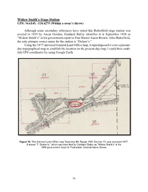
Using the 1877 surveyed General Land Office map, I superimposed it over a present-
day topographical map to establish the location on the present-day map. I could then estab-
lish GPS coordinates by using Google Earth.
Figure 16. This General Land Office map Township 6N, Range 15W, Section 13, was surveyed 1877.
It shows “T. Delano’s,” which was identified by Goddard Bailey as “Widow Smith’s” in his
1858 government report to Postmaster General Aaron Brown.
16