|
|
Cultural & Paleontological Resources:
Soledad Canyon (Southdown-Transit Mixed) Sand and Gravel Mining Project.
Report prepared by Chamber Group Inc.
Cultural Resources section by Roger Mason, Ph.D. (Anthropology).
3.1.9. Cultural and Paleontological Resources.
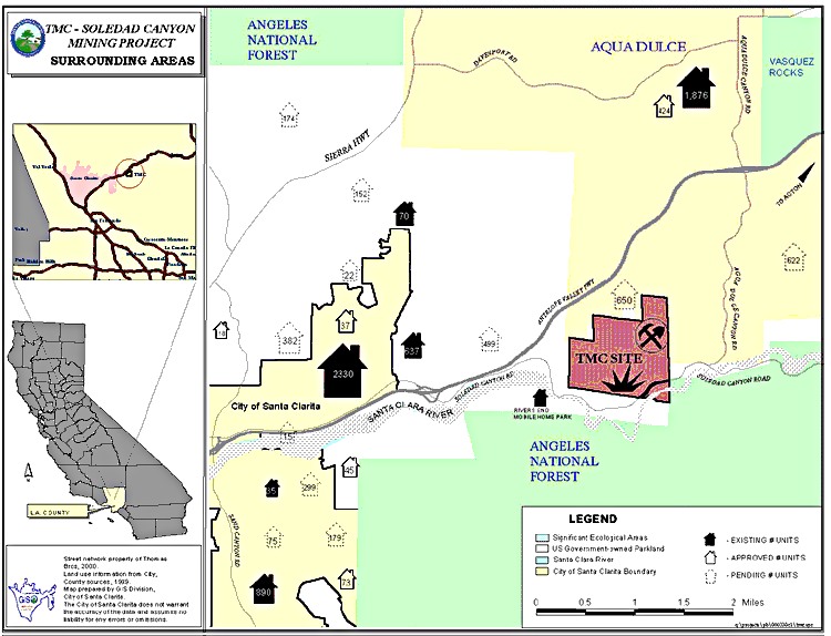
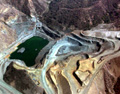
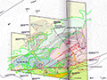
3.1.9.1. Affected Environment. To place cultural resources in their proper context, a brief overview of the prehistory, ethnography and history of the region is provided. Prehistory. Beads found in Agua Dulce-area archaeological sites indicate the region has been occupied at least since 1,000 B.C. Settlement systems during the Middle Period (circa 1,000 B.C. to A.D. 750) are poorly understood but may have been based on a seasonal round of movements among resource zones. During the Late Period (after A.D. 750), the settlement system consisted of villages occupied most of each year and located at lower elevations near permanent water sources. Resource gathering camps were located in the higher elevations. Important plant food resources included acorns, seeds, yucca and juniper berries. Game was hunted and trapped and included deer, rabbits and small carnivores. The more sedentary settlement system characteristic of the Late Period was probably based on the intensification and diversification of plant foods with less emphasis on hunting. This system may have been introduced by the arrival of Takic speakers from the southwestern Great Basin during the Middle Period. These Takic speakers were likely the ancestors of the Tataviam, the group inhabiting the region when the Spanish arrived in the late eighteenth century. Ethnography and Ethnohistory. The mountains and steep-sided canyons of the project area were inhabited by a Takic-speaking native American group known as the Alliklik or Tataviam (King and Blackburn 1978:535-537). The territory of the Tataviam centered on the Santa Clara River east of Piru Creek, mainly in the Santa Clarita Valley. Village locations near the project area include Tochonanga to the southwest near Newhall, and Agua Dulce to the northeast. Agua Dulce appears to have been a larger village, possibly operating as a major economic center. As many as 200 people inhabited larger villages, while smaller camps held 10 to 15 people. Neighboring Takic-speaking groups included the Kitanemuk in the Antelope Valley to the north, the Gabrielino in the San Fernando Valley and Los Angeles region to the south, and the Serrano to the east. The Hokan-speaking Chumas [sic] lived to the west. All these groups traded with the Tataviam. When the Spanish first came in contact with the Tataviam, their population was estimated at less than 1,000 individuals. Most of the group had been baptized at the San Fernando Mission by 1810. Disease and intermarriage with nonnative people slowly decreased their population; the last surviving speaker of the Tataviam language died in 1916 [Editor's note: the correct date is June 30, 1921]. History. While Europeans and Americans established some small farms along major drainages in the region, settlement increased with the construction of SP [Southern Pacific] Railroad through Soledad Canyon from 1875 to 1876. The San Joaquin Valley line connected Los Angeles to the Central Valley and San Francisco through the Antelope Valley and Tehachapi Pass. Soledad Canyon provided one of the few viable routes across the San Gabriel Mountains. The Lang Station, located directly southwest of the project area, was where the last spike of the railroad was driven in 1876. The station operated as a train order station for a number of years, closing in 1967 (Signor 1983:170). The SP Railroad still uses the route through Soledad Canyon, with some modifications made through the years. Metrolink uses the route for commuter service. The railroad runs through the southeast portion of the project area; Soledad Canyon Road follows the same basic route. Most of the historic activity in the San Gabriel Mountains has been related to mining. Placerita Canyon, the site of a gold strike in 1842, is located about 8 miles southwest of the project area. Since that strike, gold, copper, iron, quartz and titanium have been periodically mined from Soledad Canyon (Macfarlane Archaeological Consultants 1991:2; Lydon 1957:649). In 1921, the Sierra Highway, north of the project area, was completed. Originally, a dirt road winding through Mint Canyon linked Los Angeles with the Antelope Valley. This route has recently been replaced by Route 14, the Antelope Valley Freeway, directly north of the project area. Inventoried Cultural Resources. An archival records search conducted at the Archaeological Information Center at UCLA indicated that no cultural resources had been previously recorded within the project area but that 15 prehistoric and 2 historic archaeological sites were documented within 1 mile of the project area. The majority of the project area was surveyed by King (1974) in conjunction with an interpretive report for cultural resources present at the Vasquez Rocks County Park, and Tartaglia (1989) during a reconnaissance of Bee Canyon. No cultural resources were recorded as a result of these two separate but overlapping surveys. The remaining portions of the project area, as well as previously surveyed adjacent areas of high potential/sensitivity along Bee and Soledad Canyons, were surveyed by Chambers Group staff archaeologists on April 10, 1990. This survey located one historic archaeological site, LAN-1847H, on the project area. LAN-1847H — This historic archaeological site contains a trash scatter and two terraced areas lined with river cobbles. The terrace areas may represent the location of a residence and other structures; one area appears to represent a privy location. The trash scatter contains fragments of stoneware, milk and clear glass, sun-altered amethyst glass, and nails. The sun-altered amethyst glass suggests a date of 1890-1920. Potential for Paleontological Resources. As discussed above (Section 3.1.1.1), the project area is underlain with Vasquez Formation conglomerates that are not considered fossil-bearing. The potential for impacts on paleontological resources within the project area is very low. Eligiblity Criteria. The determination of impacts to cultural resources first requires a determination of a site's eligibility under the criteria established for the National Register of Historic Places (36 CFR 60.4). The quality of significance in American history, architecture and culture is present in districts, sites, buildings, structures and objects of state and local importance that possess integrity of location, design, setting, materials, workmanship, feeling, association and (a) That are associated with events that have made a significant contribution to the broad patterns of our history; or (b) That are associated with the lives of persons significant in our past; or (c) That embody the distinctive characteristics of a type, period or method of construction, or that represent the work of a master, or that possess high artistic values, or that represent a significant and distinguishable entity whose components may lack individual distinction; or (d) That have yielded, or may be likely to yield, information important to prehistory or history. Since the process for actually listing a site on the National Register for Historic Places can be a lengthy one, federal agencies ant the California Office of Historic Preservation can determine a site as eligible for listing on the Register, which has the same effect. Unless a resource is of exceptional important or value, sites younger than 50 years are not considered eligible for the National Register. However, it is recommended that sites 45 years old or older can be considered during the evaluation process to allow for potential delays between evaluation and project construction periods. Inventory data are often insufficient to determine the eligibility of cultural resources, particularly archaeological resources. A testing program to provide additional data may be required to determine the age of a resource, its integrity, and/or its ability to answer important research questions. Archaeological testing programs also need to be designed to discover the vertical and horizontal boundaries of a site. The data collected through a testing program are critical for determining site eligibility. Any disturbance of a potentially important/significant resource may be viewed as an adverse effect under Section 106. 3.1.9.3. Environmental Effects. A summary of federal procedures for evaluating impacts on cultural resources is provided below, followed by a discussion of project-specific impacts. Summary of Federal Procedures. Cultural resources which are listed on or eligible for listing on the National Register of Historic Places are considered significant resources. Implementing regulations of Section 106 of the National Historic Preservation Act (36 CFR 800.5) require that impacts be assessed in terms of effect. Significant impacts are those that have an "adverse effect" on characteristics that make a resource eligible for the National Register of Historic Places [36 CFR 800.9(a) and (b)]. In general, an impact is significant if it would result in damage to a site's integrity or to its research potential. Effect determinations may lead to a "No Effect" (no impacts) determination or to a "Determination of Effect" (impacts occur). In the latter case, the effect must be evaluated to determine whether there is an "Adverse Effect" or not ("No Adverse Effect Determination"). ... Project-Specific Impacts. Historic archaeological site LAN-1847H, while within the boundaries of the project, lies in a portion of the site where no ground disturbance is currently planned. The site will be avoided; thus, no significant adverse impact will occur. However, it is recommended that the site be fenced to ensure protection during construction (see Mitigation Measure CR1). Because LAN-1847H has not been excavated, its potential importance is not known. If this site were to be impacted by future construction, a test excavation program would need to be performed to determine its importance prior to any ground disturbance (see Mitigation Measure CR2). The potential for paleontological resources is low, because the area formation conglomerates are not considered to be fossil-bearing. No impacts are anticipated. 3.1.9.4 Mitigation Measures. CR1. Under current construction plans, the historic archaeological site (LAN-1847H) will be avoided. However, to ensure that the site is not disturbed by construction activities, the site will be fenced under the direction of an archaeological monitor. With this measure, the site will be avoided and protected, which is a preferred mitigation measure under CEQA. CR2. If under future construction plans the site cannot be avoided and protected, an archaeological test program that includes archival research will be necessary to determine the site's importance. If the site is found to be important, a data recovery program will be implemented to mitigate impacts on a less-than-significant level. 3.1.9.5 Unavoidable Significant Adverse Effects. The measures proposed above can be feasibly implemented and will reduce the identified impacts to a less-than-significant level. No potential significant unavoidable adverse impacts will remain after mitigation.
|
EIS: Cultural Resources 6/2000
Peer Review: Cultural Resources 12/2000
Curtis Pit 2002
County Permit 6/2/2004
|
The site owner makes no assertions as to ownership of any original copyrights to digitized images. However, these images are intended for Personal or Research use only. Any other kind of use, including but not limited to commercial or scholarly publication in any medium or format, public exhibition, or use online or in a web site, may be subject to additional restrictions including but not limited to the copyrights held by parties other than the site owner. USERS ARE SOLELY RESPONSIBLE for determining the existence of such rights and for obtaining any permissions and/or paying associated fees necessary for the proposed use.
