|
|

|
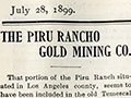
That portion of the Piru Ranch situated in Los Angeles county, seems to have been included in the old Temescal grant on account of its auriferous gravels which were at one time very rich. There has been some little dispute between Upper and Lower California as to where and when gold was first discovered in this State. The following quotation from the State Mineralogist of 1888, gives some very interesting data bearing upon the subject. Speaking of the San Filisiana [Feliciana] Placer Diggings it says: "During the period from 1810 to 1840, Jose Bermudes and Francisco Lopez* superintended the Mission Indians in working the gravel deposits. In 1842, finding that these, though worked in a crude manner, paid exceedingly well, the Mexican Government was petitioned to consider the territory between Piru Creek and the Soledad Canyon, and extending west to the Mojave desert, Mineral land and that no grant be extended taking in that territory. This petition was granted by the government. "The most extensive mining operations carried on in this belt of gravel, were in 1854, when Francisco Garcia took out of the San Filisiana Gulch, in one season, $65,000 in gold." The Piru Rancho includes the whole of this San Filisana Canyon, as well as nearly all the small gulches tributary to it. Ever since the first announcement of rich finds the ground has been worked more or less extensively. Only the closest inspection, however, will reward anything of the enormous amount of work that has been done here, for each rainy season changes the aspect of the country, not alone by leveling the mounds thrown out and filling up the excavations, but by actually reconcentrating the gold in the narrow creek beds. No idea can be had then how many times the surface gravels have been turned over and over to the bed rock, with the pan, the rocker, or the dry washer. The most noticable reminders of the early and vigorous search for gold, are the hundreds of old tunnels which riddle some of the gold-bearing hills and bars. A very striking instance of this is the seat of the present operations. The wedge-shaped hill of gravel and clay, that separates the San Filisiana from Cone Canyon, seems to be one of the few places that it was impossible to work out entirely by the crude methods previously employed. Although it has been honeycombed with a systematic network of tunnels, it is so situated as to present a very good hydraulic proposition, were water at hand for such use. The gold in this hill is not just like anything found in the vicinity, being thick and coarse. The rough conglomerate bedrock dips in toward the center of the hill from each side, forming the deep channel of some ancient river. It is down at the bottom of this ragged cut that the best gold seems to have hidden itself away from the vulgar gaze of greedy man. A long tunnel was run for several hundred feet along the channel and in one place a huge chamber was gouged out, it may be where two streams came together. Tunnels strike for this old chamber from all directions, like spokes of a wheel, while the side cuts and stoppings would make the whole very much resemble a spider's web. Of course nearly all of these tunnels are caved in now. None of them can be traversed their full length; but in many places the wind can be heard howling through the holes too small to admit a man. Three months' prospecting discovered no ground that would pay to work very long, at any other point; so we began to consider the development of water, to be used in piping off the old hill. Dams were built in the canyons and ditches run to a reservoir on top of the hill, with a view of intercepting the winter rain that did not come. And while good folks prayed for an end of dry weather, we pushed a tunnel into the hill, so that our trousers might show wear at the bottoms, as well as at the knees. We did find out where the gold was, and also where it is, for no sooner did we reach it than the ground began to give way, and today there is no trace of the opening left. Room was lacking for another tunnel in that hill and since it was getting to be too late for rain, we began to look around for worn-out springs that might be recuperated. Our investigation showed this much without a great deal of study: We were surrounded by high hills, like the walls of an amphitheater. Grouped in the various canyons, about on the same level, were the indications of superanuated [superannuated? dried out?] springs in the shape of groves of live oaks and sycamores, with green grass and bushes, and sometimes an actual showing of water. There is scarcely a large oak or Sycamore above what we may call the water level. The conclusion reached was that the precious fluid was held back by some sort of rim rock, except where the latter was worn away by natural erosion, enough to let through a seepage. More careful examination showed this rim rock to be a stratum of blue sand stone, with a dip and strike very much in accordance with that of the canyons. This rim rock is not a dyke, but a cap. True it is not horizontal, but it can be drilled through with a perpendicular hole. Our first well was made with a ten-foot hand drill, and as a result, got a tiny little stream of water flowing out over the top of the hole. Was not this artesian water? The drill was not long enough, but while waiting for another, we tried the next gulch, with the same success. A churn drill was quickly rigged up with a tripod and windlass, and a third gulch was encouraged to spout forth about 2½ inches of very fine water, the analysis of which appeared in this sheet some months ago. This method, however, was too slow, and moreover, we were not sure that the hard rock with which we were obliged to stop at 30 feet, was not holding back a large flow of water, so a portable gasoline engine was purchased and belted to a hoist rigged with a paper friction pulley. A derrick supported a sluice over which ran the single rope. Taking a couple of turns around the drum of the hoist, we jumped the 3-inch bit up and down, until the hole was deep enough to admit a length of 1½ inch iron pipe which was screwed to the bit-stock, the stalk itself being a piece of the same pipe. In order to haul pipe, lumber, and machinery into camp and from camp to the various points where the water vein was to be tapped, good roads had to be built, regardless of the roughness of the country. In spite of grading, in several places however, it was necessary to anchor at the top of a ridge and let down wagon or engine with block and tackle. At 30 feet, in the same spot where we had been drilling by hand, the bottom became so hard that progress, even with the engine, was exceedingly slow, so that after a foot or two we gave it up as a bad job and set up our rig in the next canyon about 100 yards distant and 25 feet lower down. At 50 feet we struck bedrock again, and a flow of 8 inches of water. In 10 hours our first well was drained as dry as a bone and the second had dwindled down to 4 inches. During the next week it went down to 2 inches, consequently we dropped a syphon down into it about 25 feet and increased the flow to 3 inches. In the meantime a tunnel was run in to tap the vein; but 50 feet of tunnel, cutting the vein at right angles, failed to bring more water than the first ten feet; and that was not as much as our second well was giving us. The water course proved to be a blue conglomerate, with now and again a little patch of quicksand. Clam and oyster shells were plentiful, and the tooth of a sword fish, in a most perfect state of petrification, was found embedded in the cap rock of blue sand stone. The depth of several other wells, averaged about forty feet, with an average flow of 2½ inches. The last well was sunk a little below the mouth of the water tunnel which was drained before the well was completed. The bottom of the well being some fifty feet below the tunnel, the water was doubled. Pipe lines are now laid to gather all this water into a reservoir placed on top of the hill, from which a 6-inch main leads to a sluice race at the lower end of the proposition; for we have started in to wash away the whole hill. As the bedrock is cleaned up with the hose, new sluice boxes are added, in the bottoms of which are wedged riffle boards, to catch the yellow metal as it rushes down with the gravel and dirt. The engine and hoist help us now to remove the rock and large boulders from in front of the boxes. The great difficulty being the lack of water, a centrifugal pump returns a portion of the water from the lower to the upper end of the boxes, thus keeping up a sort of forced circulation. So we work on day by day, caving down and washing through the boxes, tons upon tons of dirt and rock, knowing that the gold will remain behind the riffles. To work a bank of gravel 125 or 130 feet in height, with a small amount of water is difficult and dangerous, and quite unsatisfactory in many ways; but while we are waiting for the rains, that must sometime come to relieve this famished country, we will continue to do the best we can, being certain from previous thorough prospecting, that it is only a question of time and water before we will be amply repaid for our trouble and expense. GEO. E. COOK. * Webmaster's note: Mission records show Francisco Lopez was born in 1802. He didn't superintend anyone in 1810. Plus, it was his younger brother Pedro, and his father (Juan Lopez) before him, who "superintended" the Indians at Mission San Fernando. Free Press Brings Buyers. The new firm of Powell & Tuttle seems to be doing a big business. The fact that they are extensive advertisers doubtless accounts for much of their trade. In speaking of their trade Mr. Powell said, "Yes our trade is very good. Indeed, we find it hard to keep enough of certain lines in stock to supply the demand. We sell at retail almost as cheaply as some people buy at wholesale. By the way our FREE PRESS ads bring us big returns. I have been noticing and find that your paper not only has the largest circulation, but also that it reaches the people who have money to buy with. " Yes the FREE PRESS has brought us customers from all parts of Ventura county, and some even from Santa Barbara county. FREE PRESS and New York Tribune $2 for new, cash subscribers.
|
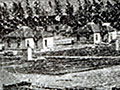
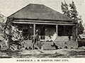
Piru City Story
Fruit Rancho Story
Piru Valley Story
Gold Mining Co.
Warring Family & Buckhorn Station
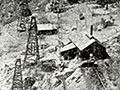
The Oil Industry
Water Supply
Camulos Rancho
|
The site owner makes no assertions as to ownership of any original copyrights to digitized images. However, these images are intended for Personal or Research use only. Any other kind of use, including but not limited to commercial or scholarly publication in any medium or format, public exhibition, or use online or in a web site, may be subject to additional restrictions including but not limited to the copyrights held by parties other than the site owner. USERS ARE SOLELY RESPONSIBLE for determining the existence of such rights and for obtaining any permissions and/or paying associated fees necessary for the proposed use.
