Geological Investigation of Future Piru Lake Site
Devil Canyon, Piru, California
|
Ventura County was growing, both in population and in acres under cultivation in the Santa Clara River Valley, and that meant it needed water like never before. So, in 1928, when a new state law encouraged water conservation, business leaders in and around Santa Paula organized the Santa Clara (Valley) Water Conservation District and set about to find ways to capture rain- and wastewater in the valley's sandy alluvium rather than let it all flow out to the sea, untapped.
In 1931, the Conservation District and the state agreed to split the cost of investigations of possible sites for dams and water storage reservoirs. Led by Verne M. Freeman, the district's managing engineer, geologists examined sites along the Sespe, Piru and Ventura rivers and took a keen interest in sections north of Piru.
According to the Venturans' political champion, state Sen. Walter H. Duval — himself a Conservation District director — the noted geologists Charles P. Berkey (1867-1955) and Paul F. Kerr particularly liked a location they referred to as "French Flats." Sadly, they were too late. The state was already invested in plans to run the Ridge Route Alternate through the area now known as Frenchman's Flat campground. Over the Venturans' vehement protestations, the state ran the Ridge Route Alternate through the coveted dam site in 1933, criss-crossing Piru Creek.
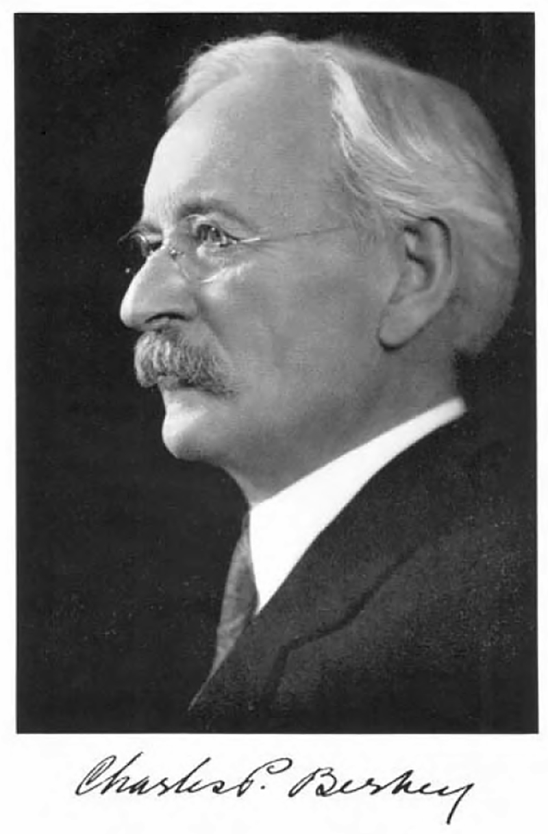
Charles P. Berkey, geologist.
|
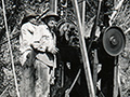
Meanwhile in July and August 1931, the geologists also examined Devil's Canyon, which is shown in this series of photographs. We aren't certain, but it looks like Charles P. Berkey at the drill in the first image.
In the end, the Devil's Canyon site was chosen, and the Conservation District constructed a dam and reservoir there — but not until 24 years later. Completed in 1955, Santa Felicia Dam impounds 82,000 acre-feet of winter runoff from the Piru Creek watershed in its reservoir, known as Lake Piru.
The images shown here consist of 3 negatives, approx. 3½x5 inches, and nine photographic prints, approx. 3½x4½ inches, developed at the time (1931) — including two duplicates.
Captions hand-written on backs of photographic prints and on envelopes containing the negatives:
LW3585a — Drill crew. Devil Canyon site, 1931.
LW3585b — Drilling ss. layer. West abutment. Devil Canyon site, 1931.
LW3585c — Piru Creek above Devil Canyon. Looking north along east wall of canyon. Note ss. strata & intermediate layers of weathered shale. July 1931.
LW3585d — Cavernous weathering of ss. about 500' south of east abutment. Piru Creek, Aug. 1931. Cave behind fence post extends into the ss. for 10' & leads to a smaller cavern on one side.
LW3585e — East abutment – Piru Creek. Devil Canyon site, 1931.
LW3585f — Fault. Piru Creek, 1931. Devil Canyon.
LW3585fb — (Detail from LW3585f.)
LW3585g — Fractured ss. Devil Canyon site. 1931.
LW3585h — (Negative file name): East abutment panorama.
LW3585i — (Negative file name): East abutment panorama.
LW3585j — (Negative file name): East abutment panorama.
Read about geologist Charles P. Berkey here.
|
Click to enlarge.
|
Water Survey Funds Given.
Ventura County Supervisors Appropriate $17,500.
This Amount Equals Sum State Provides.
Year's Additional Work to Be Assured by Action.
Los Angeles Times | June 17, 1931.
Ventura, June 16 — Faced with the fact that Ventura county must plan for a future water supply, the Board of Supervisors today, at the request of State Senator Walter Duval, voted to transfer $17,500 to the State Treasury to match and equal the sum offered by the State for a year's additional survey of the county's water resources. A like amount will be turned over next year for a similar purpose.
Duval stated that he would light indefinitely any plan to route the new cut-off from the Ridge Route through Springs Creek in the Piru section, if the survey showed that this was the best possible location for dam site, and also would oppose any plan to route the road down any canyon in the county which might later be used for reservoir purposes.
Through Duval's efforts $25,000 was assigned to Ventura county by the State Department of Public Works for the water survey, provided the county matched the sum. This survey includes an investigation of the reservoir sites with a geologic study of the dam foundations.
"Our water survey, which has been carried on for the past few years, shows that our water resources are in a serious condition," Duval told the members of the board today. "We can't tell whether the Springs Creek, Los Alamos or Devil's Canyon site may be the choice for a reserve supply of water until we make this investigation and get foundation tests. In my mind there should be two future sites set aside, one in the Sespe and one back of Piru. That is why I will oppose, strenuously, any road that goes through one of these dam sites.
"Salt water has just been found in one of the wells at Hueneme and the water is unfit for domestic or other uses. We must get the data together during a dry period so that in an abnormal rainfall year we may profit by the surplus.
"And we must have the data which will show fully our needs so that we may be prepared to tie in with the State-wide plan for water development when it comes. I am confident that 35,000 acre feet of water can be saved each year in the Piru watershed alone," Duval added.
The board voted unanimously to transfer the money for the survey to the State Treasury and Chairman T.G. Gabbert stated that he felt the board should give its fullest co-operation to developing the water resources of the county.
|
|
Click to enlarge.
|
Conservation Body Listens to Engineer.
Los Angeles Times | July 3, 1931.
Santa Paula, July 2. — Directors of the Santa Clara Water Conservation District, at their annual meeting here this afternoon, accepted the report of V.M. Freeman, engineer for the district, and the recommendations contained therein, which chiefly concerned the need of more spreading grounds in the county. Senator Walter H. Duval, chairman of the board, presided.
The directors also recommended a 10-cent district tax to provide for the budget of $20,000 needed for the work this year.
Freeman recommended that the capacity of the Saticoy spreading grounds be doubled and also recommended that such grounds be created near the Sespe Creek bed and at the mouth of Piru Creek.
A proposition of the Berylwood Investment Company, presented by Richard Bard of Hueneme, to sell to the district 100 acres for a spreading ground near the mouth oi Piru Creek for $100 per acre was heard. The matter will be investigated by the engineer and members of the board.
The members authorized Engineer Freeman to notify the State that the board desired to have borings made at once as to the possibility of dam sites at the French Flat and Alamo sections of the Upper Piru. Construction of the Ridge Route cut-off is being held up until some determination is made. If borings indicate that the proposed route of the road through this section will not destroy any possible dam sites, then objection to it on the part of the Santa Clara Conservation District will be removed.
|
|
Click to enlarge.
|
Preliminaries on Dams Begin.
Drillers Start Working in Devil Canyon Area.
Start Made in Checking for Series of Reservoirs.
Proposed Locations on Piru, Sespe and Ventura Rivers.
Los Angeles Times | August 4, 1931.
Santa Paula, Aug. 3. — With the driller now working at Devil Canyon dam site near the lower end of Piru Creek, the program of drilling for numerous reservoir sites on Piru, Sespe and Ventura rivers in this county has been started, according to a report from the State Division of Water Resources today.
A geological report has been made on all the reservoir sites in the county and at those in which doubt exists as to adequate dam formations, drilling will be done. It is most important at this time to determine conditions at the reservoir sites on Piru Creek because it is here that a conflict is possible between the new locations of the Ridge Route and the reservoir sites which might be used to salvage the Piru Creek waste, it was said.
The work of drilling is being done as a part of the investigation of the water resources in Ventura county which started in 1927 under the direction of the State Division of Water Resources and with funds furnished on an equal basis by the State and the county of Ventura.
|
|
Click to enlarge.
|
Diverting Ridge Road From Piru Canyon Sought.
Los Angeles Times | November 14, 1931.
Sacramento, Nov. 13 (AP) — The State Highway Commission discussed today a proposal by the Santa Clara Valley Water Conservation District of Ventura county that it relocate a portion of the Ridge Route alternate to avoid Piru Creek Canyon.
Members of the commission said they will decide nothing today but would continue discussions with representatives of the district. The commissioners said that abandonment of the route would cost the state an additional $1,500,000.
The district wants the road relocated because it cuts through a canyon dam site at French Flat, Los Angeles county.
[Webmaster's note: "French Flat" is the site of the current Frenchman's Flat campground, where the Ridge Route Alternate ultimately did cross Piru Creek when it was put through in 1933.]
|
|
Click to enlarge.
|
Venturans Vote Against Road at Reservoir Site
Los Angeles Times | November 17, 1931.
Ventura, Nov. 16. — Resolution demanding cessation of construction of a state highway through the French Flats reservoir site in Piru Canyon, were voted by the Ventura Chamber of Commerce at its meeting this noon.
The action followed a presentation of the subject by State Senator Duval. He said that Berkey and Kerr, consulting geologists employed by the Santa Clara Water Conservation District, had reported French Flats to be one of the best reservoir sites in Southern California, and of great potential value to Ventura county.
|
|
Click to enlarge.
|
'Not By a Dam Site,' Protest.
Conservation District Group Publicizes Battle Cry Against Cut-Off.
Los Angeles Times | December 28, 1931.
Bakersfield, Dec. 27. (AP) Ventura farmers, members of Little Santa Clara water conservation district, have made a formal complaint to the State Chamber of Commerce and are publicizing a battle cry of "not by a dam site," in an effort to prevent construction of the new Ridge Route highway cut-off through the floor of French Flats and the Los Alamos Basin in the Piru Creek watershed.
The farmers protesting assert that these locations are two of the finest dam sites in the area concerned, and that construction of the highway would prevent them from building a water run-off dam impounding water in the area of the ill-fated St. Francis Dam.
|
|

Click to enlarge.
|
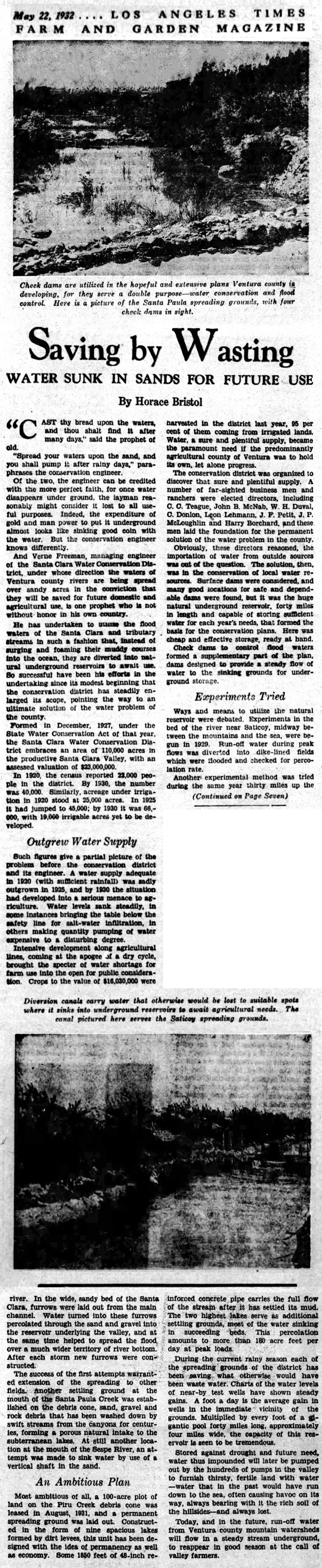
Water Sunk in Sands for Future Use.
Los Angeles Times Farm and Garden Magazine | May 22, 1932.
"Cast thy bread upon the waters, and thou shalt find it after many days," said the prophet of old.
"Spread your waters upon the sand, and you shall pump it after rainy days," paraphrases the conservation engineer.
Of the two, the engineer can be credited with the more perfect faith, for once water disappears under ground, the layman reasonably might consider it lost to all useful purposes. Indeed, the expenditure of gold and man power to put it underground almost looks like sinking good coin with the water. But the conservation engineer knows differently.
And Verne Freeman, managing engineer of the Santa Clara Water Conservation District, under whose direction the waters of Ventura county rivers are being spread over sandy acres in the conviction that they will be saved for future domestic and agricultural use, is one prophet who is not without honor in his own country.
He has undertaken to utilize the flood waters of the Santa Clara and tributary streams in such a fashion that, instead of surging and foaming their muddy courses into the ocean, they are diverted into natural underground reservoirs to await use. So successful have been his efforts in the undertaking since its modest beginning that the conservation district has steadily enlarged its scope, pointing the way to an ultimate solution of the water problem of the county.
Formed in December 1927 under the State Water Conservation Act of that year, the Santa Clara Water Conservation District embraces an area of 110,000 acres in the productive Santa Clara Valley, with an assessed valuation of $23,000,000.
In 1920, the census reported 22,000 people in the district. By 1930, the number was 40,000. Similarly, acreage under irrigation in 1920 stood at 25,000 acres. In 1925 it had jumped to 45,000; by 1930 it was 66,000, with 19,000 irrigable acres yet to be developed.
Outgrew Water Supply.
Such figures give a partial picture of the problem before the conservation district and its engineer. A water supply adequate in 1920 (with sufficient rainfall) was sadly outgrown in 1925, and by 1930 the situation had developed into a serious menace to agriculture. Water levels sank steadily, in some instances bringing the table below the safety line for salt-water infiltration, in others making quantity pumping of water expensive to a disturbing degree.
Intensive development along agricultural lines, coming at the apogee of a dry cycle, brought the specter of water shortage for farm use into the open for public consideration. Crops to the value of $16,030,000 were harvested in the district last year, 95 per cent of them coming from irrigated lands. Water, a sure and plentiful supply, became the paramount need if the predominantly agricultural county of Ventura was to hold its own, let alone progress.
The conservation district was organized to discover that sure and plentiful supply. A number of far-sighted business men and ranchers were elected directors, including C.C. Teague, John B. McNab, W.H. Duval, C. Donlon, Leon Lehmann, J.F. Petit, J.P. McLoughlin and Harry Borchard, and these men laid the foundation for the permanent solution of the water problem in the county.
Obviously, these directors reasoned, the importation of water from outside sources was out of the question. The solution, then, was in the conservation of local water resources. Surface dams were considered, and many good locations for safe and dependable dams were found, but it was the huge natural underground reservoir, forty miles in length and capable of storing sufficient water for each year's needs, that formed the basis for the conservation plans. Here was cheap and effective storage, ready at hand.
Check dams to control flood waters formed a supplementary part of the plan, dams designed to provide a steady flow of water to the sinking grounds tor underground storage.
Experiments Tried.
Ways and means to utilize the natural reservoir were debated. Experiments in the bed of the river near Saticoy, midway between the mountains and the sea, were begun in 1929. Run-off water during peak flows was diverted into dike-lined fields which were flooded and checked for percolation rate.
Another experimental method was tried during the same year thirty miles up the river. In the wide, sandy bed of the Santa Clara, furrows were laid out from the main channel. Water turned into these furrows percolated through the sand and gravel into the reservoir underlying the valley, and at the same time helped to spread the flood, over a much wider territory of river bottom. After each storm new furrows were constructed.
The success of the first attempts warranted extension of the spreading to other fields. Another settling ground at the mouth of the Santa Paula Creek was established on the debris cone: sand, gravel and rock debris that has been washed down by swift streams from the canyons for centuries, forming a porous natural intake to the subterranean lakes. At still another location at the mouth of the Sespe River, an attempt was made to sink water by use of a vertical shaft in the sand.
An Ambitious Plan.
Most ambitious of all, a 100-acre plot of land on the Piru Creek debris cone was leased in August 1931, and a permanent spreading ground was laid out. Constructed in the form of nine spacious lakes formed by dirt levees, this unit has been designed with the idea of permanency as well as economy. Some 1,850 feet of 48-inch reinforced concrete pipe carries the full flow of the stream after it has settled its mud. The two highest lakes serve as additional settling grounds, most of the water sinking in succeeding beds. This percolation amounts to more than 180 acre feet per day at peak loads.
During the current rainy season each of the spreading grounds of the district has been saving what otherwise would have been waste water. Charts of the water levels of near-by test wells have shown steady gains. A foot a day is the average gain in wells in the immediate vicinity of the grounds. Multiplied by every foot of a gigantic pool forty miles long, approximately four miles wide, the capacity of this reservoir is seen to be tremendous.
Stored against drought and future need, water thus impounded will later be pumped out by the hundreds of pumps in the valley to furnish thirsty, fertile land with water — water that in the past would have run down to the sea, often causing havoc on its way, always bearing with it the rich soil of the hillsides — and always lost.
Today, and in the future, run-off water from Ventura county mountain watersheds will flow in a steady stream underground, to reappear in good season at the call of valley farmers.
|
LW3585: Download original images here. Purchased 2019 by Leon Worden (Holabird Americana, Lot 5164, March 11, 2019).
|
Geological Investigation 1931 (Mult.)

FILM: Fishing 1957
|
|