|
|


Click image to enlarge
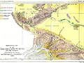
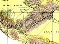
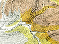
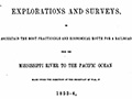
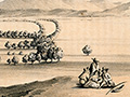
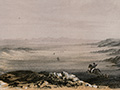
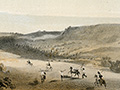
Detail from "Geological Map of the Tejon Pass & Cañada de las Uvas and the Vicinity. Including the Pass of San Francisquito & Williamsons Pass." Printed in 1856 as part of the "Reports of Explorations and Surveys, to Ascertain the Most Practicable and Economical Route for a Railroad from the Mississippi River to the Pacific Ocean, Made under the Direction of the Secretary of War, in 1853-54, According to Acts of Congress of March 3, 1853, May 31, 1854, and August 5, 1854. Volume 5. Washington: A.O.P. Nicholson, Printer, 1856." House of Representatives: Thirty-Third Congress, 2nd Session, Ex. Doc. No. 91. The map shows information derived from John C. Frémont's expedition of 1844, under President John Tyler, and of Lt. R.S. Williamson, of the Corps of Topographical Engineers (later called the Army Corps of Engineers), under the direction of newly appointed War Secretary Jefferson Davis. Of note: Cañada de las Uvas, above center to the west, is Grapevine Pass (Uvas=grapes). At top, east, is "Tah-ee-chay-pay Pass," aka Tehachapi. Below center, west, Cajon de Tenoco is Piru Creek. Williamson's Pass, named by him in 1853, is at the head of Soledad Canyon, where it feeds into the Mojave Desert. This is probably where one of the Jayhawkers, William Robinson, died a few years earlier, as detailed in The Forty-Niners in Death Valley: A Tentative Census. Williamson also named the "New Pass" on his 1853 expedition (later called the Newhall Pass), and while in Soledad Canyon, he identified the unarmored threespine stickleback fish as a separate species — thus its scientific name, Gasterosteus aculeatus williamsoni. Key to map: As shown, pink represents "Granite and Metamorphic." Blue-green is "Porphyry and Greenstone." Striped blue-green is "Limestone, Metamor(phi)c." Orange is "Uplifted Sandstone probably Eocene." Yellow is "Drift Detritus." By T. Sinclair's lith(ography), Phila(delphia). Fronticepiece to the Congressional report:
LW2143c: 1200 dpi jpeg from original map.
|
SEE ALSO:
Williamson 1853: Report (1856)
Williamson 1853: Tejon Pass Entrance (1856)
Williamson 1853: Cañada de las Uvas (1856)
Williamson 1853: Great Basin View (1856)
Williamson 1853; SCV Geological Map (1856)
|
The site owner makes no assertions as to ownership of any original copyrights to digitized images. However, these images are intended for Personal or Research use only. Any other kind of use, including but not limited to commercial or scholarly publication in any medium or format, public exhibition, or use online or in a web site, may be subject to additional restrictions including but not limited to the copyrights held by parties other than the site owner. USERS ARE SOLELY RESPONSIBLE for determining the existence of such rights and for obtaining any permissions and/or paying associated fees necessary for the proposed use.
