|
|

California Gold Discoveries Before (and After) Lopez 1842.
Published as: History of the Development of Placer Mining in California.
By William Wirt "W.W." Jenkins.
Tenth Annual Report of the Pioneers of Los Angeles County
Annual Publication of the Historical Society of Southern California | Vol. 7, No. 1, 1906 (published 1907).
|
From the auriferous deposits of the State of California, $1,100,000,000 gold have been extracted during the last sixty years. The magnitude of the mining operations required to produce this enormous yield is but little known to the general public. The continuous flow of gold bullion has, however, made the State famous and attracted the attention of political economists everywhere. First Mention of California: The first mention of the name "California" occurs in connection with the supposed great island where gold and precious stones were found in abundance, described in a romance called "Las Sergus de Esplandian," published in Spain A.D. 1510. The followers of Cortez had a chimerical idea of some hidden El Dorado, and, strange to say, they applied the name "California" to that unknown country north of Mexico with which they associated the notion of a region of fabulous wealth. Discovery of Lower California: The first expedition sent out by Cortez in 1534 discovered what is now called Lower California. According to Father Venegas, this expedition numbering some seven hundred souls, was fitted out at the Port of Tehuantepec in the year 1537 and sailed north to the head of the Gulf of California, but never reached the line which marks the southern boundary of the State of California. Contemporaneously with the departure of this party, four persons named "Alvarez Nunez," "Cabeza de Vaca," "Castillo" and "Dormente," with a negro named ''Estevancio," arrived at Culdiacan, on the Gulf of California, from the Peninsula of Florida. These were the sole survivors of the three hundred Spaniards who, in 1527, landed with Pamfilo Narvaez on the coast of Florida with the intention of conquering that country. Nunez subsequently conducted the expedition which discovered the Rio de La Plata and effected the first conquest of Paraguay. Early Explorations: In 1542, Mendoza, Viceroy of Mexico, sent Rodriguez Cabrillo, a Portuguese, to survey the west coast of California. He explored the coast, naming numerous headlands, the most northerly of which, in latitude 40 degrees north, he called Cape Mendocino. Thence he proceeded further north to latitude 44 degrees, which he reached March 10th, 1543. In 1578, Sir Francis Drake entered the Pacific and sailed north as high as latitude 48 degrees. According to Hakluyt's account of the voyage, Drake spent five weeks in June and July 1579 in a bay near latitude 38 degrees north. First Mention of Gold: The narrative says: "Our General called this country New Albion. There is no part of the earth here to be taken up wherein there is not a reasonable quantity of gold and silver." It is difficult to reconcile this statement with the facts as known at present, since in latitude 38 degrees north, neither gold nor silver exists in "reasonable quantity" near the ocean; this is, however, remarkable as the first mention of gold in California proper. In 1662 the Count de Monte Rey, Viceroy of New Spain, by order of the King, sent Sebastian Viscaino on an exploring expedition. He sailed from Acapulco, May 5, 1602, with two vessels and a tender, with Admiral Gomez in command. The expedition, composed of a large number of men, was equipped for one year's voyage. Three barefooted Carmelites accompanied the party, and the several departments were intrusted to distinguished officers, volunteers from Brittany. After the struggle with the northwest winds, on November 10th, 1602, the fleet entered the harbor of San Diego, and, having spent a few days there, the expedition again sailed north. December 16, 1602, anchor was cast in Monterey Bay, which was named in honor of the Viceroy. January 3, 1603, the fleet weighed anchor, and a period of one hundred and sixty years elapsed before this bay was revisited. January 12, the fleet passed the Bay of San Francisco, and anchored behind a point of land called "La Punta de Reyes," but did not enter San Francisco harbor. The voyage was subsequently continued as far as latitude 43 degrees north, from which point the fleet returned to Acapulco. First Mission Established in Lower California: In 1697 the first permanent Mission was established by the Jesuits at Loreta, Lower California. "These people," says the historian, "with patient art and devoted zeal, accomplished that which had defied the energy of Cortez and baffled the efforts of the Spanish monarchy for generations afterwards." First Mission in Upper California: In 1768, the Jesuits were banished from Lower California. On the ninth day of January, 1769, an expedition set sail from La Paz, in Lower California, to rediscover San Diego and Monterey. The vessels stopped at Cape St. Lucas and left that point February 15th of the said year. On the first of July, 1769, a land expedition which had started shortly after the vessel had set sail from Cape St. Lucas, under the immediate charge of Padre Junipero Serra, reached San Diego and established the first Franciscan Mission in Upper California. Notwithstanding the facts revealed by the many expeditions, the geographers of that day still persisted in describing California as an island extending from Capt St. Lucas at the Tropic of Cancer to latitude 45 degrees north, and it was not until after Father Pergert's map was published at Manheim, in 1771, that California was relieved of its insular character. Early Discoveries of Placers: At different times between 1775 and 1828, small deposits of placer gold were found by Mexicans near the Colorado River. In 1802 a mineral vein, supposed to contain silver, was found at Alisal, in the district of Monterey. In 1828 a small gold placer was discovered at San Isidoro, in what is known as San Diego county. Forbes, in his history of California in 1835, says: "No minerals of particular importance have yet been found in Upper California, nor any appearance of metals." In 1834 the placers of [Rancho?] San Francisco, Placerita and Castiac [sic: Castaic] and the San Feliciana [all in Santa Clarita Valley — Ed.], forty-five miles northwest from Los Angeles, were discovered and were worked by the San Fernando and San Buenaventura Missions between the years of 1834 and 1838, under the supervision of Francisco Lopez for the San Fernando Mission and Jose Bernudes [sic: Bermudez] for the San Buenaventura Mission. In the latter part of 1838, Francisco Garcia was piloted to and shown by Francisco Lopez the placers of San Feliciana. Garcia then returned to Sonora, Mexico, in 1839, and in 1840 came back with thirty Mexicans, Gambacinos (placer miners) and during the latter part of 1840 and the fore part of 1841, took from the San Feliciana Gulch two hundred and twelve pounds of gold avoirdupois weight, weighed by D.W. Alexander, who in the year 1855 made an affidavit to this effect. At the time above-named gold was taken from the Gulch, it was named the San Feliciana by Garcia, and has retained its name to the present day. Jose Salazar, one of the men brought from Sonora, Mexico, by Garcia returned to the San Feliciana in the latter part of 1841, and from one tunnel took forty-two thousand dollars, after which he remained at the San Feliciana Ranch, now known as the Newhall Ranch, and married the widow of the late Jose Antonio Del Valle. After the rush of 1855-6 to Kern River, Slate Range and Cerro Gordo and what is now known as Randsburg, many of these people drifted into the San Feliciana, Castiac [sic] and San Francisquito. During the years 1857 and 1858 there was not less than six thousand people mining for gold in the last named places. In 1854 W.W. Jenkins and Sanford Lyon, at the instance of and with Francisco Lopez, visited the oil springs, from whence the Mission San Fernando took the oil in rawhide bags to the mission, where it was distilled for lighting purposes. We also visited all of the gold fields referred to and obtained all the information and history in the possession of Francisco Lopez. In the year 1858, W.W. Jenkins and Cyrus Lyon purchased from Jose Espenosa [sic] one nugget from which was realized $1,928, which was the largest piece known to have been taken from this locality. In 1841, Wilkes' exploring expedition visited the coast, James B. Dana, mineralogist, accompanying the party. In the following year in his work on mineralogy, Dana mentions that gold was found in the Sacramento Valley and that "rocks similar to those of the auriferous formations" were observed in Southern Oregon. May 4, 1846, Thomas O. Larkin, United States Consul at Monterey, said, in an official letter to James Buchanan, Esq., then Secretary of State: "There is no doubt that gold, silver, quicksilver, copper, lead, sulphur and coal mines are to be found all over California, and it is doubtful whether, under their present owners, they ever will be worked." On the 7th day of July, 1846, the American flag was hoisted at Monterey and the country taken possession of by the United States. Marshall Discovers Gold at Coloma: January 19, 1848, James W. Marshall, while engaged in digging a race for a saw mill at Coloma (thirty-five miles east from Sutter's Fort) found some pieces of yellow metal which he and a half dozen men working with him at the mill supposed to be gold. He felt confident that he had made a discovery of great importance, but he knew nothing of either chemistry or gold mining, and he could not prove the nature of the metal or tell how to obtain it in paying quantities. So Marshall's collection of specimens continued to accumulate and his associates began to think there might be something in his gold mine after all. In the middle of February, Bennett, one of the party employed at the mill, went to San Francisco, and returned with Isaac Humphreys, a man who washed gold in Georgia, and who, after a few hours' work, declared the mines to be richer than those of his own state. By means of a rocker, he obtained daily about one ounce of gold and soon all the hands of the mill were rocking for the precious metal. The record of the discovery of gold, as related by Parsons in his biography of Marshall, is somewhat different from that published by Brown, and gives to Marshall alone the credit of discovery. Other Gold Discoveries: Pierson B. Redding, the owner of a large ranch at the head of the Sacramento Valley, visited the mining works at Coloma and immediately resolved to commence washing on his own property, which he thought was of a similar formation, and in a few weeks he had begun mining on a bar on Clear Creek, nearly two hundred miles northwest from Coloma. His example was followed by John Bidwell, who, having seen Sutter's works, commenced prospecting on the bars of Feather River, seventy-five miles northwest from Coloma. In February 1848, the treaty of Guadalupe-Hidalgo was made, and Mexico ceded California to the United States. By the end of the same year mines were opened at far distant points. Miners were working in every large stream on the western slope of the Sierra Nevada, from Feather River to the Tuolumne, a distance of one hundred and fifty miles. First Publication of Gold Discoveries: The first printed notice of the discovery of gold appeared in the "California," a newspaper published in San Francisco, on March 15, 1848. On May 2d, the same paper announced that its publication would be suspended, the whole population having betaken itself to the mines. In 1849, the placers of Trinity and Mariposa were opened. At this period hired men were the exception, every man worked for himself and rocker claims were very abundant. In 1850, the deposits of Klamath and Scott's Valley were discovered. First Attempt to Build Ditches: The chief want of the placer mining being water, the first noteworthy attempt at ditch-building was made in March 1850 at Coyote Hill, Nevada County. In the spring of the same year gold was reported as lying on the banks of Gold Lake, near Downieville. This caused a tremendous excitement and a rush of miners to that locality. In a few weeks thousands returned from the lake poorer than when they started. On September 9, 1850, California was admitted into the Union as a State. The number of persons then engaged in mining was estimated at fifty thousand. River mining at this period occupied a prominent place in the industries of the State. First Use of the "Long Tom": The winter of 1849-50 was very stormy and comparatively little work was done in the rivers and creeks, but in the spring of 1850 mining was resumed on those bars which were subject to overflow only at extreme high water. The pick, shovel, rocker, and wheelbarrow were the only implements then in use. Towards the end of 1850 the "Long Tom" was introduced. Discovery of Gold Quartz Veins: Extensive prospecting at this period for the source of these gravel deposits led to the discovery of gold quartz mines, the most noted of which was the Allison Ranch mine in Nevada County. In 1851 came the rush to Gold Bluff, latitude 41 degrees north. The work on dry bars gradually led to mining the river bottoms, which was first undertaken by means of wing dams. Later the most venturous miners turned entire streams from their courses by means of flumes or ditches. First Working of Deep Deposits: Simultaneously the miners "pushed back" from shallow placers to deep deposits, which were worked by means of the "Long Tom," and with the advent of sluices in 1851 the low hill gravels were attacked and successfully mined. Coincident with the introduction of the sluice and washing of hill gravels came the employment of hired men in placer diggings. Sluicing: The deep deposits of auriferous gravel were relatively poorer than the shallow placers, and open cuts, preparatory to sluicing, these were requisite; a large supply of water ditches became a necessity, labor was in demand, but without capital nothing could be accomplished. The sluice revolutionized gold-washing. With the exhaustion of the surface diggings the river towns fell into decay, and those mountain districts where the deep auriferous beds were found soon became the prosperous counties of the State. First Use of the Hydraulic Method: It was evident that the sluices ran dirt faster than the shovellers could supply it, labor was expensive, men receiving from $6 to $8 per diem, and the claims were poor compared with the washings of 1849-50. In 1852, Edward E. Mattison of Connecticut, with a view to economizing in labor, used a stream of water under pressure. For this purpose water was conveyed to the claim in rawhide hose and discharged through a wooden nozzle against a bank. Torn loose by water, the earth was carried into sluices, and shoveling was thus avoided. A large saving in the cost of mining was effected, a greater amount of material being washed in a shorter time. This was the first step in hydraulic mining. Canvas Hose: Mattison's experiments were immediately appreciated and his methods adopted. Hose made of canvas was widely used, the canvas being strengthened by netting and bound with rope. Iron Pipe: Towards the end of 1853, pipes made of light sheet-iron were introduced as a substitute for canvas hose. The first iron pipe was used by R.R. Craig on American Hill, Nevada County. It consisted of about one hundred feet of stove pipe. In 1858 a firm in San Francisco commenced the manufacture of wrought iron pipes for hydraulic mining, and during the years 1856-57 a large sheet-iron pipe forty inches in diameter was laid for a water conduit across a depression at Timbuctoo, in Yuba County. Inverted Siphons: In 1869 a wire suspension bridge across the Trinity River, near McGillivray's, was constructed by Joseph McGillvray. This bridge supported a fifteen-inch wrought iron pipe which conducted water from a ditch situated at an elevation of about two hundred and forty feet above the bridge. The length of the pipe was nineteen hundred and eight feet, and the outlet was one hundred and thirty-three feet below the level of the inlet. In the fall of 1870 the Spring Valley Company of Cherokee, Butte County, laid the first large "inverted siphon" in the mining regions. The siphon was made of wrought iron, riveted. It was thirty inches in diameter and fourteen thousand feet long, crossing a depression of nearly one thousand feet. Improved Nozzles: With the substitution of sheet iron pipe for canvas, it was necessary to retain a short piece of canvas hose in order to obtain a flexible discharging piece. This was inconvenient and troublesome. The ingenuity of the miners was aroused, and the result was the introduction of a nozzle called the "Goose Neck," which was flexible iron joint formed by two elbows working one over the other. First Riffle: The radius plate, or riffle, was patented by C.E. Macy in 1863, and was subsequently introduced and used in all metallic jointed discharge pipes which had elbows. The next improved hydraulic nozzle was invented by the Messrs. R.R. and J. Craig of Nevada County. It was called Craig's Globe Monitor. This nozzle proved a success and was adopted at once by the miners. Subsequently the Hydraulic Knuckle Joint and Nozzle was invented by H. Fisher of Nevada County and took the place of the Craig machine. In 1870, Mr. Richard Hoskins patented the nozzle called the little Giant, which was an improvement on the Dictator, and has to a great extent superseded the older inventions. Deflector: The next advance in hydraulic discharge machines was an attachment to the nozzle called the "deflector," the invention of Mr. C.H. Perkins, and patented in May 1876. This is a short piece of pipe, about an inch larger in diameter than the nozzle attached to the latter by a gimbal joint and operated with a lever. This improvement has been followed by the invention of the Hoskin's Deflector. This latter is a flexible semi-ball joint between the end of the discharge pipe and the nozzle. It is operated by a lever. In 1852-53 placer mining was at the height of its prosperity. Labor was well paid and employment was easily obtained by all who sought it. At this period, there still remained a few of the rich surface deposits which had formerly been so numerous. First Drift Mining: The first extensive drift mining in the old river channels was commenced in 1852 at Forest Hill, Placer County, though in 1851 a surface claim at Brown's Bar, on the middle fork of the American River, was drifted out by Joseph McGillivray. In 1854, in consequence of the reported discovery of gold diggings in Kern County, California, numbers of miners flocked to the southern part of the State, only to find there poor deposits on a very limited area. Table Mountain: Some miners engaged in sinking a shaft near Jamestown, Tuolumne County, where the gravel had been washed away, discovered gold at Table Mountain. Simultaneously other miners traced a seam of gravel containing gold along its sides, and it was found that this seam ran into a deep, rocky channel lying under the mountain. The presence of water in great quantity frustrated all attempts to work this deposit. Deep Tunnels: Further explorations developed the existence of channels running under this ridge, which was found to have a westerly course and to pitch deeper as work advanced. After several ineffectual attempts to drain the deposit, the gravel, which proved later to be exceedingly rich, was finally bottomed by a deep tunnel. "Ten feet square, superficial measurement, yielded $100,000, and a pint of gravel frequently contained a pound of gold." An impetus to deep gravel mining or drifting was given by these developments, and extensive explorations of a similar character was undertaken subsequently in other parts of the State. During the years 1856-57, river, bar and gulch mining were less productive, but quartz and ditch interest became more valuable. The Frazer River excitement of 1857 caused a stampede of miners and speculators to British Columbia. The subsequent developments of these gravel fields occasioned loss to those who had been attracted thither by the desire of gain. In 1859-60 came the exodus to the Comstock, and in 1862 the rush to Idaho followed. Hydraulic mining gained ground steadily from 1852 to 1856. As the river bars and surface diggings, one after another, became exhausted, the working of the old river deposits by the hydraulic process became a necessity. At the present time it is by this modern method of mining that the bulk of the gold of this State is produced, and in this business nearly $100,000,000 of capital are invested. The hydraulic process is now carried on upon such a gigantic scale and to so vast an extent as to require the assistance of the science of hydraulics and engineering. Heretofore, apart from the construction of ditches and tunnels necessary for washing the gold-bearing dirt, engineers have had but little to do with the management of hydraulic claims. The primitive placer mining of 1852 to 1865 has passed into history. Forty-inch wrought iron pipes have been substituted for canvas hose and stove pipes, and with the replacing of nine-inch nozzles under 450-foot pressure, the last remnant of the early methods have disappeared. In the early days, placer mining was only profitable when values ran high, but such improvements have been made in means and methods that the hydraulic Giants profitably handle gravel banks that have values of not to exceed seven cents per yard. While hydraulic mining has been bringing the large gravel deposits to a producing stage the dredgers have been placed on the rivers and sloughs and are handling the deep deposits at great profits when they have value of as low as six cents per yard, one dredge often handling as much as five thousand cubic yards a day. These great improvements have been most marked in the placer fields where water is plenty and easily available. In the dryer portions of California are enormous gravel deposits that carry values of one dollar per yard and higher, and these have never been worked except by the dry washer, for the reason that water was not available. But science has again come to the rescue and now it has been demonstrated that what was supposed to be desert mountains is now the covering to great inexhaustible deposits of water, and modern pumps are now pouring this water on this rich gravel and washing out its riches. Cañon Diablo, San Feliciana, La Palomas, Castiac [sic], San Francisquito, Dry and Texas Cañons in Los Angeles County are all coming forward as producers and will add millions to the wealth that has been taken from the placer mines of California. "Water is King and that King bringeth forth, for his use Crowning Gold."
Download individual pages here.
|
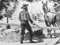
An Arrastre
1838 Shipment
Pre-1842 Discoveries & Later Mining Techniques, by W.W. Jenkins 1906
SEE ALSO:
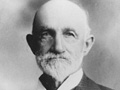
W.W. Jenkins, 1835-1916
Story of Bill Jenkins Pre-1842 Gold Discoveries & Later Mining Techniques, by W.W. Jenkins 1906
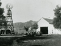
Lazy Z ~1895
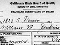
W.W. Jenkins Death Cert 10-19-1916
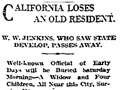
Obituary
|
The site owner makes no assertions as to ownership of any original copyrights to digitized images. However, these images are intended for Personal or Research use only. Any other kind of use, including but not limited to commercial or scholarly publication in any medium or format, public exhibition, or use online or in a web site, may be subject to additional restrictions including but not limited to the copyrights held by parties other than the site owner. USERS ARE SOLELY RESPONSIBLE for determining the existence of such rights and for obtaining any permissions and/or paying associated fees necessary for the proposed use.
