
Page 87 - ssmtmp2_final20181211
P. 87
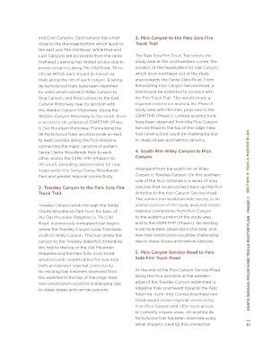
DelVa lle Rd ¨ § Z Dr Figure 4-1: Trail Network Gaps and Barriers Dr and East Canyons. Each canyon has a trail 3. Pico Canyon to the Palo Sola Fire
¨ § Z
5
Gaps and Barriers
Plum Canyon Rd
Rd Commer ce Center Dr Copper Hi ll Dec oro D r DelVa lle Rd Commer ce 5 ll Plum close to the drainage bottom which leads to Truck Trail
1. Wiley Canyon to East Canyon
Canyon Rye Canyon R d Newhall R anch Rd Bouquet Canyon Rd Copper Hi Dec oro D r Canyon Rd the east and The Old Road. While Rice and The Palo Sola Fire Truck Trail enters the
2. Towsley Canyon to the Palo
Rd
Sola Fire Truck Trail
East Canyons are accessible from the same
3. Pico Canyon to the Palo Sola
Canyon
Chiquito Ã Æ McBean Pkwy Santa Clarita Center Dr Newhall Bouquet Canyon Rd trailhead, Leaming has limited access due to study area at the southwestern corner, the
Fire Truck Trail
126
4. South Rim Wiley Canyon to
Pico Canyon.
location of the headwaters for Salt Canyon,
private property along The Old Road. These
Sole dad Canyon Rd
Santa Clara River Trail 8 8 1 10 0 Valen cia Blvd 5. Pico Canyon Service Road to Rye Canyon R d Pkwy Santa Clarita official MRCA trails should be linked via which drain northeast out of the study
Chiquito
Palo Sola Fire Truck Road
R anch Rd
6. Towsley Canyon to Pico
area towards the Santa Clara River. From
trails along the rim of each canyon. Existing
126
Canyon Service Road
17
17
7. Towsley Canyon Road to Lyons
the existing Pico Canyon Service Road, a
de facto/social trails have been identified
Gold e
Ranch Along Lower Foothills
Clara River Trail
Ã Æ n Valley Rd
9 9 Macbe a n Pkwy 8. Santa Clara River to Santa McBean Sole dad Canyon Rd by users which connect Wiley Canyon to trail should be extended to connect with
Condor
16
16
Clarita Woodlands
Trail
15 1 111 9. West from The Old Road Paseo 8 8 1 100 Blvd Rice Canyon, and Rice Canyon to the East the Fire Truck Trail. This would create a
15
Pico Canyon Trail Wiley Canyo n Rd 10. The Old Road West Utility Valen cia Gold e n Canyon Motorway near its junction with regional connection and link the Phase II
Corridor
Lyons Ave
study area with the trails proposed in the
the Weldon Canyon Motorway. Along the
à Æ
11. Pico Canyon Drainage
17
Santa ¨ § Z 12. Rice to East Canyon Sierra Hwy 17 Pkwy Valley Rd Weldon Canyon Motorway to the south, there SSMFTMP (Phase I). Limited existing trails
126
13. South Rim of Wiley Canyon to
5
Palo Sola Truck Road
5 5 Trail 6 6 7 7 17 14. East Canyon Trailhead to 9 9 Macbe a n is access to the proposed SSMFTMP (Phase have been observed from the Pico Canyon
Condor
17
16
Service Road to the top of the ridge. New
I) Oat Mountain Motorway. Formalizing the
Weldon Mountainway Trailhead
west of I-5
SECTION 4: TRAILS MASTER PLAN San Ferna ndo Rd Yarnell St 6 6 7 7 ¨ § Z Ã Æ Sierra other, and to the SSMFTMP (Phase I) to Canyon. SECTION 4: TRAILS MASTER PLAN
3 3 The Old Rd 16 Rd de facto/social trails would provide an east trail construction could be challenging due
15
15. Valencia Marketplace
4 4 2 2 16. Vista Valencia Golf Course 15 1 111 Canyo n to west corridor along the Pico Anticline to steep slopes and narrow canyons.
à Æ
1 14 4te 5 Freeway
Phase II 1 13 3 11 17. Intersta 14 Pico Canyon Trail Wiley Lyons Ave Hwy connecting the major canyons of eastern 4. South Rim Wiley Canyon to Pico
112 2
Santa Clarita Woodlands Park to each
126
the south, providing opportunities for new
¨ § Z
5
210
Westward from the south rim of Wiley
5 5
loops within the Santa Clarita Woodlands
17
17
Canyon is Towsley Canyon. On this southern
Park and greater regional connectivity.
canyons that could connect back up the Pico
Walnut Ave
Anticline to the Pico Canyon Service Road.
Truck Trail
1 144
Alamo St Los Blvd Roxford St 3 3 4 4 2 2 The Old Rd Ã Æ 2. Towsley Canyon to the Palo Sola Fire side of the Pico Anticline is a series of long
This connection would provide access to an
Simi Valley Ã Æ Phase II 1 133 11 14 Towsley Canyon winds through the Santa unseen portion of the study area and create
Balboa
Rinaldi St
Dr Angeles 118 1 122 regional connections from Pico Canyon
E Los Angeles Ave Ã Æ Ventura County San Fernando Mission Blvd Clarita Woodlands Park from the base of
Yose mite Ave
Kuehner 118 Chatsworth St the Oat Mountain Ridgeline to The Old to the eastern portion of the study area,
and to the SSMFTMP (Phase I). No existing
Rd County Mason Ave Devonshire St Road. A previously unmapped trail begins trails have been observed in this area, and
where the Towsley Canyon Loop Trail leads
Cany on 1 Los Angeles Study Area San ¨ § Z Yarnell St south to Wiley Canyon. This trail climbs the new trail construction could be challenging
210
due to steep slopes and narrow canyons.
Marilla St
canyon to the Towsley Waterfall. Extending
Plummer St
17 Box Gap Areas Ferna ndo Rd this trail to the top of the Oat Mountain
17
County Adopted Proposed
2 Ã Æ SANTA SUSANA MOUNTAINS TRAILS MASTER PLAN - PHASE II Existing County Trail Roxford St Ridgeline and the Palo Sola Truck Road 5. Pico Canyon Service Road to Palo SANTA SUSANA MOUNTAINS TRAILS MASTER PLAN - PHASE II
Canoga Ave
Sola Fire Truck Road
27
20
20 Valley Circle Blvd Roscoe Blvd Walnut Ave De Soto Ave Winnetka Ave Existing Conservancy Trail would provide opportunities for new loop At the end of the Pico Canyon Service Road
trails and greater regional connectivity.
Existing Non-LA County Trails
Woodlake Ave Fallbrook Ave Saticoy St Sherman Way Existing Bikeways Los Blvd No existing trail has been observed from along the Pico Anticline at the western
Regional Trails
the waterfall to the top of the ridge. New
edge of the Towsley Canyon watershed, a
Alamo St
Metro ATSP Corridors
trail construction could be challenging due
Simi Valley Dr I 0.5 1 1 2 Miles Ã Æ Balboa Rinaldi St to steep slopes and narrow canyons. ridgeline rises southward towards the Palo
Yose
I
0 0.5
Sola Fire Truck Trail. Connecting these two
2
0
mite
Phase II.b E Los Angeles Ave Ave Angeles Miles 118 San Fernando Mission Blvd roads would create regional connectivity
à Æ
Kuehner
DISCLAIMER: Some trails shown do not exist currently and are planned for the Date Map Created/Revised: 10/6/2017 Author: James Powell from Pico Canyon and offer users access
future, or they exist but ar 118 gnated. Permission to use trails Basemap: Los Angeles County Enterprise GIS, ESRI Data and Maps 2016 to currently unseen areas. An existing de
shown on this map should not be assumed. Some trails may traverse private Data Sources: Los Angeles County Enterprise GIS, City of Santa Clarita 2016,
property and suggested alignments do not imply rights of public use. California Protected Areas Database 2016b, Santa Clarita Valley Master Plan of Chatsworth St facto/social trail has been observed using
Trails 2015, California Recreational Trails Plan 2011, Los Angeles County
General plan 2007, Newhall R Plan 2003
80 Mason Ave Devonshire St aerial imagery creating this connection. 81
Rd
Ventura County
Cany on 1 Los Angeles Study Area
County
Marilla St
Plummer St Gap Areas
Box
17
17 County Adopted Proposed
2 Circle Blvd Ã Æ Existing County Trail
27
20 Roscoe Blvd Canoga Ave Existing Conservancy Trail
20
Valley Ave De Soto Ave Winnetka Ave Existing Non-LA County Trails
Existing Bikeways
Woodlake Fallbrook Ave Saticoy St Sherman Way Regional Trails
Metro ATSP Corridors
I 0 0.5 1 2 Miles
Phase II.b