
Page 2 - squires2012
P. 2
74 & Contributions in Science, Number 520 Squires: Pico Formation Paleontology
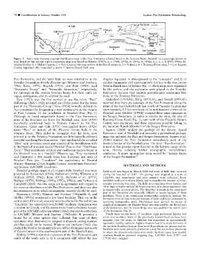
Figure 1 Index map showing outcrop-distribution map of the Pico Formation (slanted lines) in the Ventura Basin. Newhall-area outcrops (shown in
box) based on this present report; remaining map area based on Dibblee (1987a, b, c; 1988; 1990a, b; 1991a, b; 1992a, b, c, d, e, f; 1993; 1996a, b).
Specific locales: 1 5 Holser Canyon; 2 5 Pico Canyon, the type section of the Pico Formation; 3 5 Valencia; 4 5 Running Horse area; 5 5 Los Angeles
County Aqueduct (the ‘‘cascades’’); and 6 5 Stetson Ranch Park area.
Pico Formation, and the latter beds are now referred to as the Angeles Aqueduct is aboveground at the ‘‘cascades’’ and 2) in
Towsley Formation of early Pliocene age (Winterer and Durham, another prominent cliff approximately 1.8 km to the east, in the
1962; Kern, 1973). English (1914) and Kew (1918) used Stetson Ranch area of Sylmar (Fig. 1). Both areas were examined
‘‘Fernando Group’’ and ‘‘Fernando formation,’’ respectively, by the author, and the exposures were placed in the Towsley
for outcrops in the eastern Ventura Basin, but these units are Formation because they include greenish-gray sandstones like
vague, ambiguous, and should not be used. those of the Towsley Formation.
Kew (1923) was the first worker to use the name ‘‘Pico’’ Oakeshott (1958:81), Ehlig (1975:14), and Powell (1993:43)
(following Clark’s 1921 informal use of this name) for the lower reported that there are outcrops of the Pico Formation along the
part of the ‘‘Fernando Group.’’ Kew (1924) formally defined the trend of the San Gabriel Fault just north of Placerita Canyon and
Pico Formation by designating a type section area in the vicinity approximately 1.5 km northeast of the northeastern corner of the
of Pico Canyon, 11 km northwest of Newhall Pass (Fig. 1). Newhall area. Dibblee (1996b) mapped these same outcrops as
Although he listed megafossils found in the Pico Formation, the Saugus Formation. In order to resolve the issue, the area of
none of his localities are from the Newhall area. Kew (1924) Running Horse Road (Fig. 1), just north of the Placerita Nature
incorrectly correlated beds in Elsmere Canyon to his Pico Center, was examined, and these exposures possibly belong to
Formation. Grant and Gale (1931) over-applied Kew’s (1924) the Sunshine Ranch Member? of the Saugus Formation.
name ‘‘Pico’’ to include all the Pliocene marine beds in the Squires (2008) studied the geology of the Eocene Juncal
Ventura Basin. They failed to recognize that the beds, now Formation east of Newhall and provided a generalized geologic
referred to as the Towsley Formation, are lithologically different map that included the Pico and Saugus formations. Squires et al.
from the overlying Pico Formation. They subdivided the so-called (2006) studied the Pico Formation immediately west of the
‘‘Pico’’ unit into three zones and correlated the fossiliferous beds western border of the Newhall area. The term ‘‘Pico Formation’’
in the Newhall area just west of Newhall Pass to their ‘‘San Diego is used in this present report because of the historic usage of the
Zone.’’ They mistakenly referred any molluscan species found in term, thereby reducing further stratigraphic nomenclature
the Newhall area to a ‘‘middle’’ Pliocene age. They mentioned confusion. A more appropriate term would be ‘‘marine facies
and illustrated a few fossils from four localities just west of of the Saugus Formation.’’
Newhall Pass (see ‘‘Localities’’ for equivalency to Natural
History Museum of Los Angeles County Invertebrate Paleontol- MATERIALS AND METHODS
ogy Section [LACMIP] localities).
Detailed geologic maps of all or part of the Newhall area were Field work was begun in March 2006 but most of field time occurred
prepared by Rynearson (1938), Oakeshott (1958), Winterer and during the last half of 2011. The geology was mapped at a scale of
Durham (1958, 1962), Kern (1973), Barrows et al. (1975), 1:12,000, and megafossils and rock samples were collected. Every
Nelligan (1978), Dibblee (1991a, 1992a, 1996a), and Yerkes and available road and trail was hiked, and a considerable amount of cross-
Campbell (2005). No two maps are in agreement with regard to country traversing was done. The field area comprises steep terrain, and
the outcrop distribution of the Pico Formation, and there are also 30-m-high or higher vertical cliffs are common, as is dense vegetation that
inconsistencies as to which stratigraphic name(s) should be used. is impenetrable in many places. The shoreface deposits in the uppermost
part of the formation are especially difficult to access because of these
Rynearson (1938), Winterer and Durham (1962:table 4), and problems. There is no continuous stratigraphic section to measure the
Dibblee (1992a) mentioned a few fossil localities. They are in the formation from its base to its top because of faults and local incisement by
central part of the study area and were recollected by the author (see overlying stratigraphic units. Thicknesses were derived by means of
‘‘Localities’’ for equivalency to LACMIP localities). Rynearson was graphical techniques: the Elsmere Ridge area was used for the fluvial part
a student at Caltech, and his senior-thesis fossil collections became of the formation, and the Gavin Ridge area was used for the marine part
part of the LACMIP collection when Caltech donated its collections of the formation (Fig. 2).
to LACMIP. Winterer and Durham (1962:table 4) provided a Fossils were studied from 15 localities: eight previously known and
faunal list of some species they collected, but none of their seven new localities. Some of the previously known localities have been
specimens were illustrated or assigned a museum catalog number assigned, over the years, to different but equivalent or approximately
and they could not be located. Winterer and Durham (1962) also equivalent locality numbers. Approximations had to be made for some of
the previous localities because their word descriptions are inexact and the
studied the benthic foraminifera fauna of Pico Formation just north localities were never precisely plotted on a map but are in close proximity
of Gavin Canyon in the southwestern part of the Newhall area. to where the present collections were made. In those cases, new locality
Dibblee (1991a) reported exposures of the Pico Formation just numbers based on personal mapping (e.g., LACMIP locs. 17917 and
south of the study area in 1) a prominent cliff where the Los 17918) were assigned.