Geology of Southeastern Ventura Basin, Los Angeles County, California.
A study of the stratigraphy, structure, and occurrence of oil in the late Cenozoic Ventura basin.
|
Abstract. (Map below.)
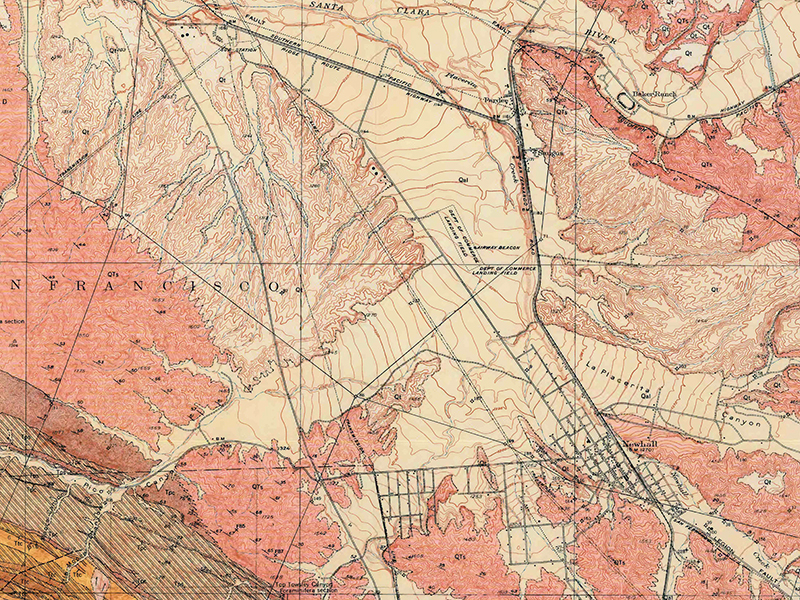
The late Cenozoic Ventura basin, Ventura and Los Angeles Counties, Calif., is an elongate sedimentary trough which, together with its deformed structures, trends approximately east-west. The mapped area of this report lies entirely within Los Angeles County. Most of the southeastern part of the Ventura basin is in the Santa Clara River watershed. Old high-level erosion surfaces, some more than 3,000 feet in altitude, and younger, topographically lower river-terrace surfaces and deposits are conspicuous. The river valley is now partly filled with alluvium which is being dissected during the present cycle of erosion. Pre-Cretaceous basement rocks exposed in the San Gabriel Mountains are the oldest rocks in the area. These rocks include the fractured schist, gneiss, quartzite, and marble of the Placerita formation of Miller (1934) and also the somewhat gneissic Rubio diorite of Miller which intrudes them. Both of these rock units are intruded by quartz plutonites ranging in composition from granite to quartz diorite. Outside the mapped area, a large body of anorthosite and norite makes up part of the basement rocks. Within the mapped area, the oldest sedimentary rocks are well-indurated sandstone and siltstone containing a marine fauna indicative of a middle Eocene or early late Eocene age. Some wells in the area have penetrated several thousand feet of Eocene rocks. Some wells drilled near San Fernando Pass have penetrated varicolored unfossiliferous beds that overlie Eocene rocks and are overlain by upper Miocene marine strata. These varicolored rocks have a thickness of nearly 2,000 feet but do not crop out in the area. They do not appear to interfinger with the overlying marine beds and are tentatively correlated with the Sespe formation of late Eocene to early Miocene age. Near the Aliso Canyon oil field, wells have been drilled through as much as 2,500 feet of strata; predominantly sandstone but including a layer of amygdaloidal basalt, correlated tentatively with the Topanga formation of middle Miocene age. Rocks representing the Luisian (middle Miocene) stage of Kleinpell overlie these strata. The nonmarine Mint Canyon formation of late Miocene age is present in the northeastern part of the area, north of the San Gabriel fault. This formation consists of flu viable sandstone and conglomerate and lacustrine siltstone and tuff and has a thickness of at least 4,000 feet north of the mapped area. The marine Modelo formation, of late middle and late Miocene age, is exposed in the southwestern part of the area but is not present in the subsurface section east of Newhall and Saugus and is not recognized north of the San Gabriel fault. Westward from the town of Newhall, its thickness increases to at least 5,000 feet at the Ventura County line. The formation is chiefly siltstone, mudstone, and shale, but it also contains sandstone and conglomerate.
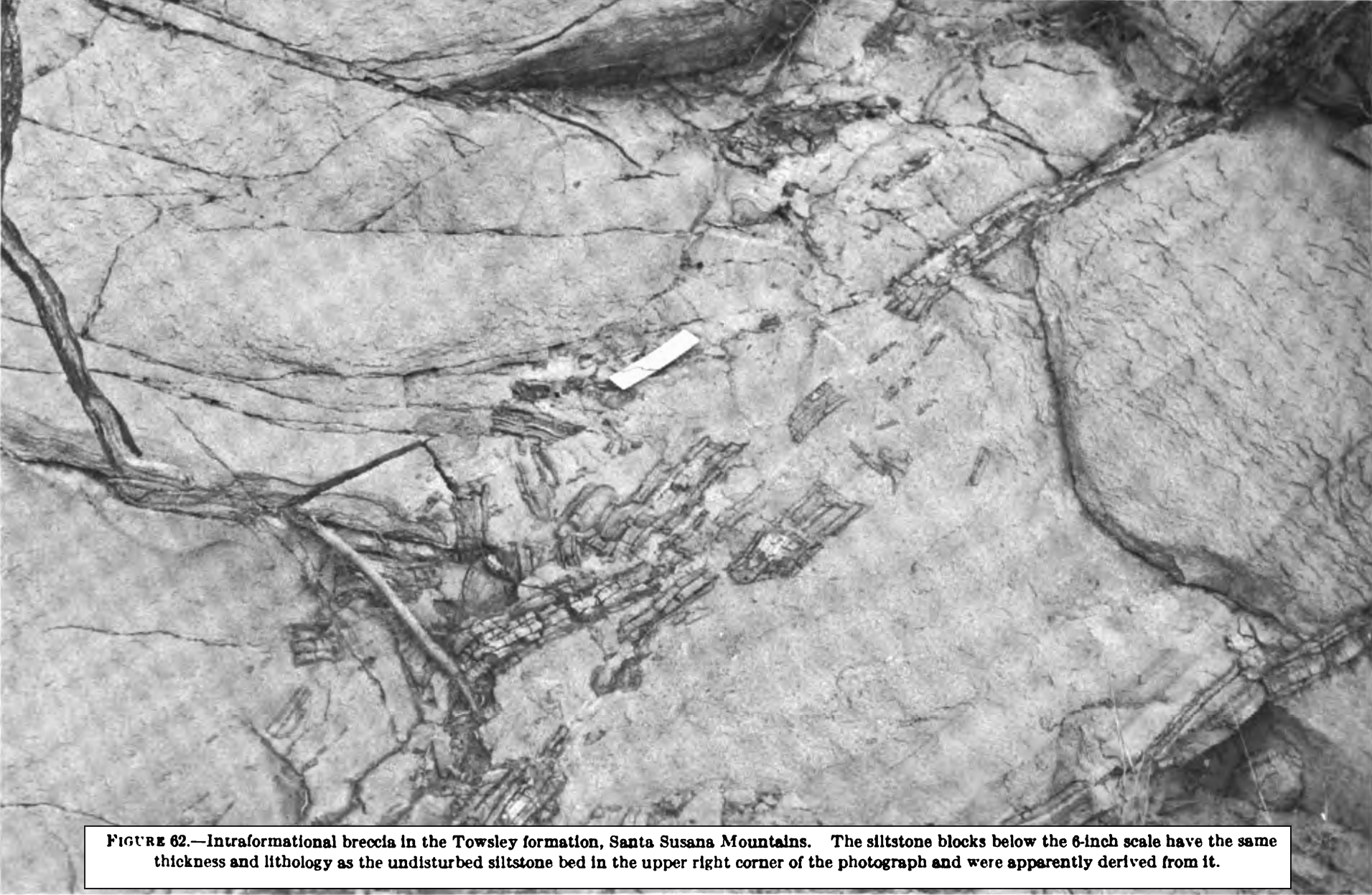
The Towsley formation, of late Miocene and early Pliocene age, overlies and in places interfingers with the Modelo formation. Near Newhall and San Fernando Pass it overlaps the Modelo formation and lies directly on the Sespe(?) formation and on Eocene and pre-Cretaceous basement rocks. The formation ranges in thickness from about 4,000 feet in the southwestern part of the area to 0 [zero] where it is overlapped by younger rocks to the east. In the Santa Susana Mountains, it grades upward into the Pico formation. Beds assigned to the Towsley formation rest unconformably on the Mint Canyon formation north of the San Gabriel fault. The Towsley formation consists chiefly of interfingering lenticular beds of sandstone, mudstone, and conglomerate. Clasts in the conglomerate beds are of rock types found to the east and northeast in the San Gabriel Mountains. Sandstone and conglomerate beds in the Santa Susana Mountains contain many sedimentary structures, including graded beds, load casts, intraformational breccias, current ripples and lineations, slump structures, and convolute bedding. At several localities, graded sandy beds contain mixed assemblages of shallow- and deep-water mollusks, the latter representing depths of more than 600 feet. The sedimentary structures and fossils, taken together, indicate that marine turbidity currents were major factors in the transportation and deposition of the sediments that now constitute the Towsley formation. A study of the molluscan fauna of the Towsley formation indicates that the shallow-water species are allied to Recent faunas now living south of the latitude of the Ventura basin. The Pico formation, of Pliocene age, is distinguished from the Towsley formation largely by its soft olive-gray siltstone that generally contains small limonitic concretions. In the area near San Fernando Pass, the Towsley and Pico interfinger, but farther to the northeast there is an unconformity at the base of the Pico. Although the Pico is marine, it interfingers with brackish-water and nonmarine beds belonging to the basal part of the overlying Saugus formation. Near the west edge of the area it is at least 5,000 feet thick. Most of the sedimentary structures suggestive of turbidity currents found in the Towsley are also present in the lower part of the Pico in the Santa Susana Mountains. Abrupt lateral gradations from siltstone to sandstone and conglomerate are common in the Pico. Molluscan faunas of mixed depth assemblage in the Pico formation suggest turbidity currents as a mode of deposition. The southern affinities of the shallow-water species suggest that the surface water temperature in the Ventura basin during the Pliocene was somewhat warmer than that prevailing now in the Pacific Ocean near Ventura. The northern affinities of the deeper water species indicate that the water was cold enough at depth to accommodate them. The vertical sequence of foraminiferal faunas suggests a gradual shoaling from water depths of about 2,500 feet in the deeper parts of the basin at the beginning to very shallow water depths at the close of Pico deposition. Lateral changes in foraminiferal faunas, shown by the crossing of foraminiferal correlation lines (water-depth lines) by lithologic units deposited by turbidity currents (time lines), indicate that at any one time the water was shallowest near Newhall and became deeper toward the west. Turbidity currents deposited coarse sand and gravel on this west-sloping bottom. The Pico formation grades upward and laterally into the Saugus formation, of Pliocene and early Pleistocene age, which consists of interfingering shallow-water marine, brackish-water, and nonmarine beds that in turn grade into exclusively non-marine beds. Sandstone, conglomerate, and reddish- and greenish-gray siltstone are characteristic of the formation. South of San Fernando Pass it is practicable to divide the Saugus formation into a lower member, the Sunshine Ranch member, characterized by greenish-gray siltstone beds, and an upper, coarser grained member. In this area the marine and brackish-water Sunshine Ranch member is separated from the upper nonmarine member by an unconformity. North and west of San Fernando Pass, the division of the Saugus formation into members is difficult, if not impossible. The thickness of the Saugus formation probably exceeds 7,000 feet in the west-central part of the area. Stream-terrace deposits of late Pleistocene age are very similar lithologically to parts of the Saugus formation. East of Saugus these deposits are as much as 200 feet thick and lie with marked unconformity on the Saugus formation. The Ventura basin is a narrow trough, filled with sedimentary rocks, whose axis approximately coincides with the Santa Clara River valley and the Santa Barbara Channel. The narrow troughlike form did not begin to develop until near the beginning of the Miocene epoch. Near the south margin of the Ventura basin the thick section of upper Cenozoic rocks has been thrust southward along the Santa Susana fault toward the older rocks of the Simi Hills. The southeastward-trending San Gabriel fault transects the northeastern part of the basin. Dissimilar facies in the pre-Pliocene rocks on opposite sides of this fault indicate a long period of continued movement along it. The major folds and faults between the San Gabriel and Santa Susana faults trend northwestward; most of the faults are southward-dipping reverse faults. The first successful oil well in the area was completed in 1875. Most of the early development was in the Newhall oil field along the Pico anticline and near the southeast margin of the basin near the San Gabriel Mountains. Interest in the petroleum possibilities of the region was renewed with the discovery of the Newhall-Potrero oil field in 1937. Discovery of the Del Valle oil field (1940), Ramona oil field (1945), Castaic Junction oil field (1950), and a second period of development in the Placenta oil field (1948) followed. More than 80 million barrels of oil were produced from wells in the area, and at least 236 nonproductive exploratory wells were drilled prior to June 30, 1953.
[
Open .pdf
]
|