|
|
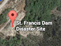
San Francisquito Canyon

Click image to enlarge The St. Francis Dam was located approximately 7.2 miles north of today's intersection of Copper Hill Road and San Francisquito Canyon Road in Saugus. To get there (as of 2016), type "St. Francis Dam Disaster Site" into Google Maps or [click here]. The upper road identified as San Francisquito Canyon Road is the one you drive on. About a mile past the stop sign at Stator Lane (the Powerhouse 2 community), you'll see an open dirt area and K-rail off to the right. Park in front of the K-rail and walk down the lower road identified on the map as San Franciquito Canyon Road. The pinpoint on the map that says "St. Francis Dam Disaster Site" is the location of the dam itself. You'll see a mound of rubble where the "Tombstone" stood. The wing dyke at the top of the hill (the west abutment) is circled in blue.
|
Self-Guided Tour
Anniversary 2001
Anniversary 2016
Anniversary 2017
Drone Video 3/12/2017
Midnight 3/12/2018
|


The site owner makes no assertions as to ownership of any original copyrights to digitized images. However, these images are intended for Personal or Research use only. Any other kind of use, including but not limited to commercial or scholarly publication in any medium or format, public exhibition, or use online or in a web site, may be subject to additional restrictions including but not limited to the copyrights held by parties other than the site owner. USERS ARE SOLELY RESPONSIBLE for determining the existence of such rights and for obtaining any permissions and/or paying associated fees necessary for the proposed use.
