|
|
Part 3: Perils of the Ridge Route.
By Alan Pollack, M.D.
| Heritage Junction Dispatch, September-October 2015.
|
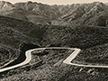
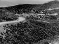
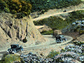
In its heyday, the Ridge Route was the scene of many an auto calamity. Take an incident reported by the Los Angeles Times on Sept. 20, 1920: "A turkey was saved, but a woman was killed and four persons injured yesterday afternoon at Caswell's, a mountain station on the Ridge Route, when an automobile driven by Thomas Limbert of Long Beach overturned as the driver swerved to avoid hitting the bird." Limbert was injured in the accident, while his wife Gussie was killed. The nearest telephone turned out to be eight miles away at Sandberg's Hotel. It took several hours to get an ambulance to the scene of the crash. Speeding on the Ridge Route was so dangerous that in August 1921, a Justice Baird announced that anyone arrested for driving over 25 mph on the road (which had a speed limit of 15 mph) would be thrown in prison.
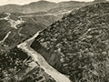
The County Speeders' Court In spite of Baird's dire warning, the mishaps and speeding were to continue. Almost one year later, the Times reported on a day in the county speeders' court of Justice Forbes. On that day, 320 cases were heard. The fines for the day totaled $3,625, and in the preceding five months, a total of about $55,000 was paid out by motorists for violating the traffic regulations. Less than two weeks after the court marathon, a speeding motorist failed to negotiate a curve on the road and plunged his auto 250 feet to the canyon floor. The four passengers in the car were taken to Glendale Hospital. "It was declared nothing less than miraculous that they escaped instant death. According to reports, their injuries consisted of many cuts, bruises and broken bones, but all will recover, it is said." The Highway Commission announced in March 1924 that it would spend $24,000 to increase safety of travel over the Ridge Route by "daylighting" and widening curves over the next few months. And yet the carnage continued. Two months later, a wealthy resident of Portland, John Straight, was killed while riding in a car driven by Portland Banner Courier reporter Earl Brownlee. The vehicle in which the two men were riding veered off of a 150-foot embankment two miles north of Castaic. Brownlee escaped with minor injuries. In August of the same year, Constable Jack Pilcher of Newhall responded to a collision on the Ridge Route. According to his report, a large touring car driven by Frank Moran with five passengers was forced off the road by two oncoming cars and rolled 30 feet down a mountainside. The other cars failed to stop after the crash. Moran's car overturned twice on its way down the mountain. The injured passengers were taken to Newhall Community Hospital by passing motorists. Among the injuries were three skull fractures and a broken arm. The skull injuries were considered possibly fatal. Widening, Straightening the Ridge Route Again in 1926, the California Highway Commission approved an allotment of $42,000 to continue widening and straightening operations on the Ridge Route between Castaic School and Reservoir Summit. The widening project had already been under way for two years. The funding for the improvements came from maintenance funds furnished by a gasoline tax and motor vehicle license fees. According to the L.A. Times, "The Ridge was originally located and built more than ten years ago, but the standards adopted are not adequate for the traffic of the present. The present Highway Commission has been endeavoring to remedy the condition by removal of as many of the dangerous points as possible and considerable straightening of the road has been done, with the hearty approval of users of the route." As if navigating the dangerous curves were not bad enough, there was also outlawry to contend with on the Ridge Route. There was a report in July 1926 of a daring daylight robbery thwarted on the highway nine miles south of Sandberg's. Two 20-year-old thugs were captured minutes after pummeling 54-year-old Glendale resident C.A. Pamerson over the head with an automatic pistol. Pamerson was found unconscious in his car covered with blood and suffering three long gashes on his head. He was rushed to Newhall Community Hospital where his condition was listed as serious. The outlaws had hijacked the car and kidnapped the injured driver. They were finally captured one-quarter mile north of the National Forest Inn when a patrol car of the Automobile Club of Southern California saw the hijacked car being driven erratically as it headed toward them. The officers turned the patrol car across the highway, blocking the path of the highwaymen, and easily arrested them. The criminals were taken to Newhall and turned over to Constable Jack Pilcher. They were lodged in the Newhall Jail for the night. Tragic Accidents on the Ridge Route In the winter of 1927, two men slipped off of the highway in snowy conditions and plunged 300 feet to the canyon below. Officers found the crushed bodies in a new sedan, which was described as a complete wreck. An improvised stretcher was made, and two deputy sheriffs along with other bystanders toiled to pull the bodies back up the steep cliff with ropes.\ As reported in the L.A. Times of Dec. 25, 1927, "The car, according to deputies, evidently went over the cliff somewhere between midnight and daylight as the bodies were cold when located by the officers. Apparently the machine had slipped on the snow while taking a sharp curve and rolled over and over down the bank, leaving a trail at points where it touched as it dropped. Patches of blood on the snow added to the gruesomeness of the find."
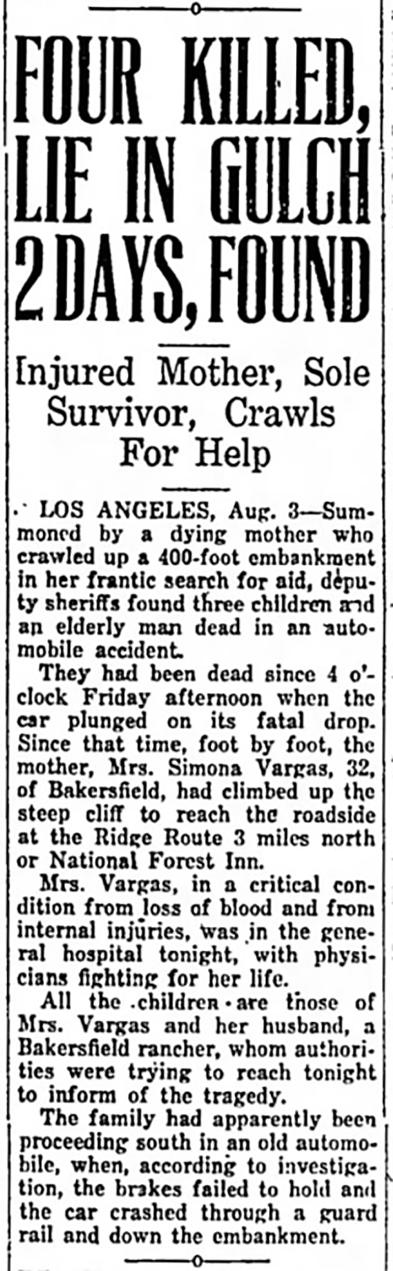
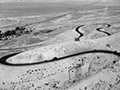
An especially tragic crash occurred in August 1929. Thirty-two-year-old Simona Vargas climbed up a 200-foot embankment while seriously injured three miles north of the National Forest Inn. She flagged down a passing motorist and revealed a horrifying mishap. Her five children and her father, Daniel Vargas, were killed when the auto's brakes failed, causing the car to crash through a guard rail and plunge down the embankment. Simona, the only survivor of the crash, made her report at the Sheriff's Substation in Newhall. Four of the bodies were found an additional 200 feet from the wreckage. Daughter Inez, the youngest victim, was only 18 months old. Two months later, a truck driver heroically plunged his truck over a 300-foot precipice to avoid crashing the heavily loaded vehicle into a group of motorists stalled on the highway. The truck tumbled end-over-end down the embankment and pinned the driver and his two passengers beneath the wreckage. Luckily all three survived the crash, but the driver suffered a concussion, fractured skull and facial lacerations requiring 25 stitches. The Ridge Route Alternate Finally on Dec. 22, 1929, plans for construction of an alternate road for the Ridge Route were announced by the California Highway Commission. The new road was to be built between Castaic and Gorman with a far easier grade and fewer curves, reducing the distance of the drive by seven miles. The project would relocate a 26-mile section of the original Ridge Route to a more westerly location and lower elevation, thereby avoiding numerous heavy grades and curves. The original road was felt to be at its maximum capacity for travel, resulting in excessive hazards due to traffic congestion, numerous and extremely sharp turns, and snow and fog in the winter months. The new highway would be capable of handling 12,000 or more cars per day, while the old road was already overloaded with 1,500 cars daily. Under agreement with the Los Angeles County Board of Supervisors, the old Ridge Route would be taken over by the county, while the state would be relieved of any further maintenance costs. The doom of the famous Ridge Route was sealed in January 1930 when the California Highway Commission authorized condemnation proceedings for the new alternate Ridge Route. The new highway would have only one-fifth of the curvature of the old road. The maximum grade of the new route was set at 6 percent. It would eliminate two of the three summits existing along the original road. The cost of the new road was originally estimated to be $3.4 million, but the final cost turned out to be only $2.0 million as a result of favorable construction bids and reduced costs of materials. The Automobile Club, advocating for the new road, pointed out that it would bring the northern and southern parts of the state closer together by at least one hour's driving time for automobiles, "having the effect of moving the vast agricultural area of San Joaquin Valley bodily from forty to fifty miles closer to Los Angeles markets and shipping points." The Automobile Club further predicted a tremendous economic savings to the entire state due to reduced shipping costs of oil, machinery, cotton, grapes, general merchandise and other products of manufacture and agriculture.
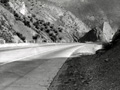
The Ridge Route Alternate road finally opened to traffic Oct. 29, 1933. Opening-day ceremonies were held at Channel Change about midway between Castaic and Gorman on the new highway. Alfred Harrell, a Bakersfield publisher, was master of ceremonies that day, with brief speeches given by representatives of Public Works, the California Highway Commission, the Auto Club, Los Angeles Chamber of Commerce, Kern and Los Angeles County boards of supervisors, state Division of Highways and California Highway Patrol. Gates at both ends of the road were opened at 10 a.m. to allow thousands of motorists to attend the ceremonies. Motorists were requested to return to their cars immediately afterward to facilitate clearing of the highway. The Los Angeles Times reported: "A short time after the highway was officially accepted by Harry Hopkins, Chairman of the California State Highway Commission, in behalf of Governor Rolph, the new ribbon of cement was throbbing to the beat of thousands of motors and echoing the tune of singing tires that sang a song of progress. ... The closing act of the ceremony was the cutting of a barrier of blue and gold ribbons across the new highway by Chairman Hopkins." Today, short segments of the Ridge Route Alternate can still be seen running to the west of Interstate 5, although a significant portion of the route is now covered by Pyramid Lake. On the old original Ridge Route, there is one spot toward the top of Serpentine Drive where one can stand and look out in the distance to see all three versions of the roads that run between Castaic and Gorman — the 1915 road, the 1933 alternate, and Interstate 5. Truly a sight to behold. Alan Pollack, M.D., is president of the Santa Clarita Valley Historical Society.
|
SEE ALSO:
Ridge Route Series
Story by Harrison Scott 2004
Auto on Ridge Route ~Late 1910s
1918-1930
1920s
Castaic Area ~1920s
Serpentine Drive x2
Ridge Route ~1930s
Grapevine Grade (Mult.)
Speed Warning 1920s
Graceful Turns ~1930s
4-26-1937
Film: Gorman to Grapveine, Winter 1939
|

The site owner makes no assertions as to ownership of any original copyrights to digitized images. However, these images are intended for Personal or Research use only. Any other kind of use, including but not limited to commercial or scholarly publication in any medium or format, public exhibition, or use online or in a web site, may be subject to additional restrictions including but not limited to the copyrights held by parties other than the site owner. USERS ARE SOLELY RESPONSIBLE for determining the existence of such rights and for obtaining any permissions and/or paying associated fees necessary for the proposed use.
