|
|
Tumble Inn (Mountainview Lodge)
On The Ridge Route
[Return To Tumble Inn Listing]
[FULL VIEW]

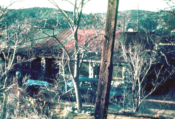
South face of the Tumble Inn in December 1944. Photo was taken from the location of the cottage; the Mill family's Dodge and its trailer are backed into the front yard. The stairway and arch are just visible.The Tumble Inn, aka Mountain View Lodge, was located on the Ridge Route four miles south of the former Sandberg's Summit Hotel and roughly midway between the current Castaic Lake reservoir and Gorman. It is not known when it was built nor exactly when it was torn down. Today all that remains are the concrete steps that led to the cabins; part of the rock perimeter wall and some of the ground-level masonry.
Ridge Route historian Harrison Scott writes:
[The Tumble Inn] is on the left side of the road; it is listed on topography maps of 1926, 1931, 1933 and 1937. The touring guide of 1928 states: "rooms, dbl. $2, meals, gas, free camp space, water and rest rooms." It is described as a small resort with a far reaching vista. The buildings were constructed of round stones, with the garage and lunch room structures level with the grade of the highway. Steps to a higher terrain located the rest rooms and lodge accommodations. The garage sold Richfield gasoline. At some point in time, the name was changed to "Mountain View Lodge." During road construction, this site was one of the larger construction camps for workers.
Paul T. Mill, whose family operated the inn when he was a child during World War II, notes that the Forest Service discouraged private land ownership within its boundaries and, "when they couldn't lease it out any more, they bulldozed it down, calling it an 'attractive nuisance.' I gather that there were one or two lesees after my family."
Mill writes:
What I saw when I was there was a main dining room with gas lights and the remains of one or more cabins above the retaining wall. The garage was way too well-built for just keeping the owner's cars out of the sun. All equipment was gone at that time, of course. But I got the idea that it was part of the business.
I cannot visualize the northwest corner of the inn. There might have been a room, maybe two available inside the inn. [The porch windows were covered in lattice work, and] an old-fashioned "sittin'" porch ran along the south and east sides of the inn. I believe the south and east walls of the house proper were also stone.
The garage on the north side if the Inn was in poor shape. The rock walls were OK, but there was no floor and I believe no door. I remember an out-building on the west side was down, too. Mom called canyon to the west and north Rattlesnake Canyon, but that may have been a ruse to keep me from wandering. (It worked!)
Online photo only.
The site owner makes no assertions as to ownership of any original copyrights to digitized images. However, these images are intended for Personal or Research use only. Any other kind of use, including but not limited to commercial or scholarly publication in any medium or format, public exhibition, or use online or in a web site, may be subject to additional restrictions including but not limited to the copyrights held by parties other than the site owner. USERS ARE SOLELY RESPONSIBLE for determining the existence of such rights and for obtaining any permissions and/or paying associated fees necessary for the proposed use.