|
|
Fillmore to Camulos (Sespe & Piru Creeks)
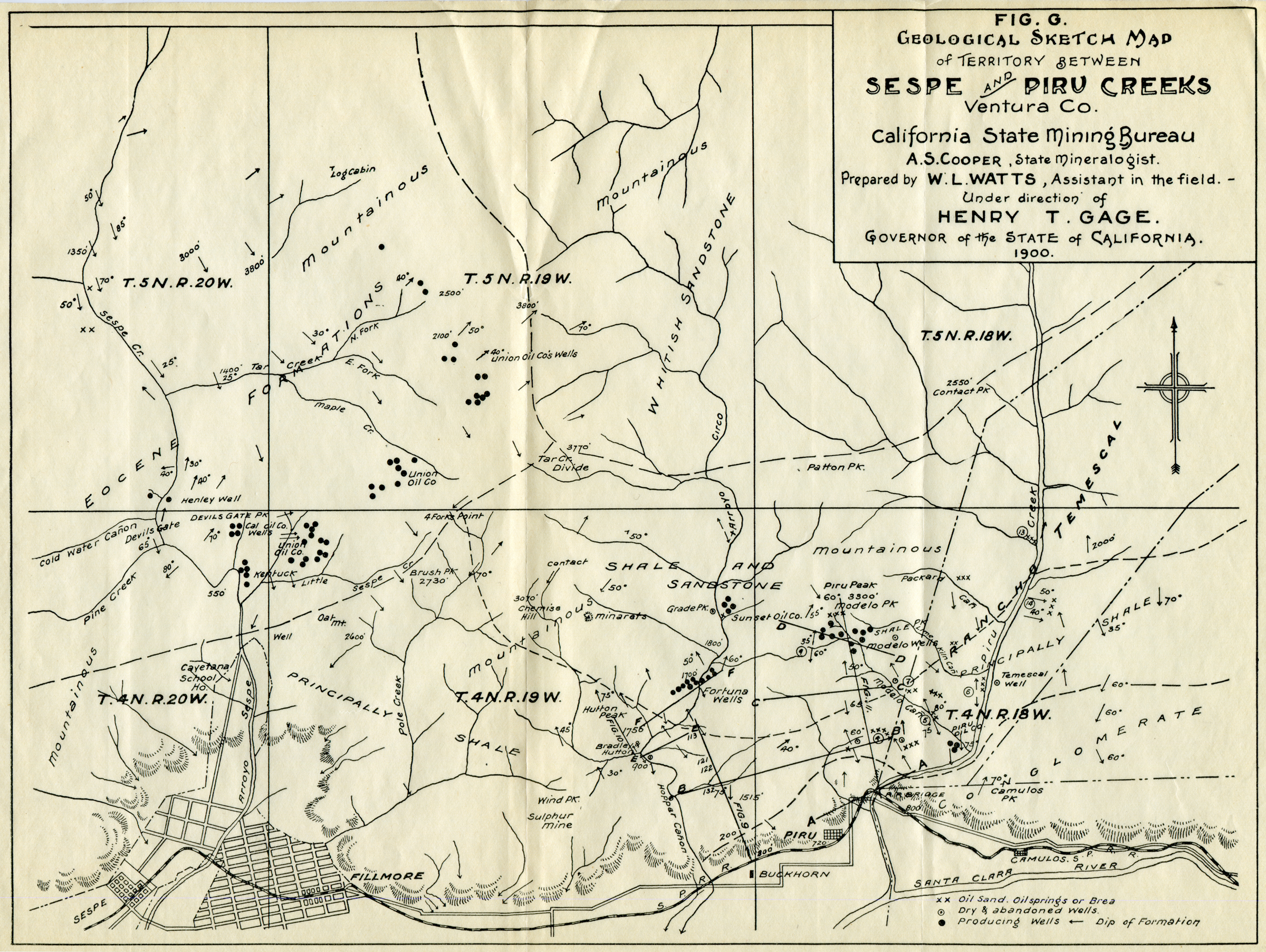
Click image to enlarge Oil well locations in the Sespe and Piru creek watersheds, 1900. California State Mining Bureau map, 8½x11 inches, paper vellum. Sespe Creek empties into the Santa Clara River at Fillmore and Piru Creek meets the Santa Clara between Piru and Camulos, so the map shows oil well locations — and identifies their owners — between Fillmore and Camulos, and in the mountains to the north of those communities. Map prepared by W.L. Watts, field assistant to A.S. Cooper, state mineralogist. Note that Henry Gage, our own Acton gold mine owner, is governor of California.
LW2560: 19200 dpi jpeg from original map purchased 2013 by Leon Worden. |
Newhall Area 1901/02
Fillmore to Camulos 1900
Land Ownership 1921
|
[ RETURN TO TOP ]
[ RETURN TO MAIN INDEX ]
[ PHOTO CREDITS ]
[ BIBLIOGRAPHY ]
[ BOOKS FOR SALE ]
SCVHistory.com is another service of SCVTV, a 501c3 Nonprofit • Site contents ©SCVTV
The site owner makes no assertions as to ownership of any original copyrights to digitized images. However, these images are intended for Personal or Research use only. Any other kind of use, including but not limited to commercial or scholarly publication in any medium or format, public exhibition, or use online or in a web site, may be subject to additional restrictions including but not limited to the copyrights held by parties other than the site owner. USERS ARE SOLELY RESPONSIBLE for determining the existence of such rights and for obtaining any permissions and/or paying associated fees necessary for the proposed use.
The site owner makes no assertions as to ownership of any original copyrights to digitized images. However, these images are intended for Personal or Research use only. Any other kind of use, including but not limited to commercial or scholarly publication in any medium or format, public exhibition, or use online or in a web site, may be subject to additional restrictions including but not limited to the copyrights held by parties other than the site owner. USERS ARE SOLELY RESPONSIBLE for determining the existence of such rights and for obtaining any permissions and/or paying associated fees necessary for the proposed use.
