(Emphasis added)
Landfill & Ecology Corps requested that Cooper Engineers conduct an assessment to determine the preliminary feasibility of developing a sanitary landfill in the Elsmere Canyon area located southeast of the Interstate 5, Interstate 210, and State Route 14 Freeway Interchange Complex near Newhall, California (See Figure A). The preliminary feasibility assessment was completed to the extent that a firm decision can be made to commit to additional engineering, environmental, and implementation efforts needed to permit the site and start operations. The preliminary feasibility investigation focused on evaluating major environmental constraints, reviewing geotechnical, geological, and hydrogeological factors of the site, reviewing the need and availability of waste for the site, p paring preliminary development alternatives, and conducting a preliminary economic assessment.
Elsmere Canyon and its southerly tributaries provide good topography for a canyon landfill. There is a divide, separating the site into a northern and southern section.
The feasibility investigation focused on development of the northern and central areas first, primarily on properties owned by Barbara Letourneur and Chevron, USA. Three development options were investigated:
- Alternative 1 - Full utilization of the central and part of the northern section of the property (950 acres); capacity of 140 million tons; re-route the LA Department of Water and Power power transmission lines.
- Alternative 2 - Develop the same general area as Alternative 1 (950 acres); capacity of 60 million tons; however, keep the power lines in their current location and fill around them.
- Alternative 2 - Utilization of the Latourneur parcel only (160 acres); capacity of 9,000,000 tons; keep power lines in their current locations.
The site appears well suited for development into a municipal solid waste (MSW) disposal facility meeting the requirements of a Class III disposal site. This new classification has recently been adopted State Water Resources Control Board and is equivalent to the old Class II-2 classification. No liquid or hazardous wastes would be accepted. Our assessment includes the following findings, conclusions and recommendations:
- The site appears suitable for development into a municipal solid waste disposal site (no liquid or hazardous wastes; only refuse and inert wastes).
- There will be a shortfall of 6,000 tons/day of landfill capacity due to landfill closure by the beginning of the 1990s. The City of Los Angeles Toyan landfill is expected to close by 1985 (2,000+ tons/day) with no alternative available in the near future. A large portion of this shortfall is in the Los Angeles and San Fernando Valley area. Some of this shortfall is expected to be absorbed by waste-to-energy facilities.
- The potential waste supply must be attracted to this facility through market agreements and a competitive price.
- The nearby Sunshine Canyon Landfill would be a direct competitor for this waste stream. However, its long-term capacity to accept these wastes are dependent on getting approvals for expansion from the City and County of Los Angeles. There has been significant citizen opposition to this expansion. Disposal fees at Sunshine appear to be higher than the proposed fees at Elsmere Canyon.
- Based on a waste supply of 2,000 tons/day, the site could be operated at a tipping fee of about $3.90/ton during its first year of operation assuming the use of all new equipment. These fees could be reduced by about $0.30 ton if used equipment is purchased.
- The facility would have an ultimate life of over 200 years, if utility lines are moved, assuming a 2000 ton/day waste input (Alternative 1). The life would be about one half of that (100 years) without the movement of utility lines (Alternative 2). The site would have 12 years of life using only the center parcel (Alternative 3).
- There appears to be no geotechnical, geological, or hydrogeological factors mitigating the suitability of the site. The pertinent geotechnical findings are as follows:
- Sufficient cover material can be generated on site through excavation and ripping.
- The underlying groundwater is insignificant in quantity, likely is contaminated by naturally occurring deposits of tar and oil, and would have little beneficial use. Based upon known information the site should not pose a threat to contamination of usable groundwater.
- Natural slope stability appears to be relatively good, except for the dip-slope area south of Fremont Peak. This area is not considered for development at this time.
- There are no known active faults within the property which would preclude development of the site as a disposal site for MSW.
- Further investigation is necessary to determine if sufficient low-permeability material is on-site for final cover and liner purposes. However, the climate and groundwater conditions are such that other design methods should be available to preclude the need for low permeability materials.
- A capital investment of about $200,000 is needed to support perm it procurement activities (engineering, EIR, etc.). About $3 to 4 million of capital would be needed for site improvements, property acquisition, and equipment for each of the three alternatives. An undetermined amount would be needed eventually to relocate utility lines for Alternative 1.
- A preliminary environmental investigation concluded that there appear to be no unmitigatable environmental impacts.
- The permitting and environmental assessment process should begin as soon as possible. Based on the history of other similar projects, a time frame of 1-2 years or longer to complete this process may not be unreasonable.
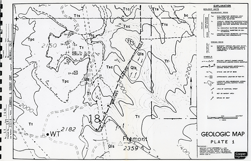
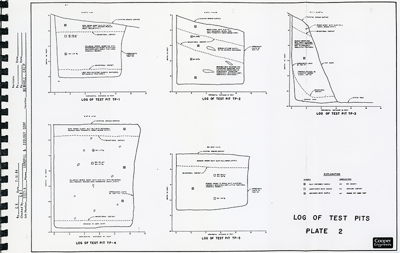
OVERSIZED MAP: TEST PITS

Click to enlarge.

Click to enlarge.
Download original pdf
here. Collection of Connie Worden-Roberts.


