Locations of Butterfield's Overland Mail Stations
from San Fernando Mission to Posey Creek (including SCV)
|
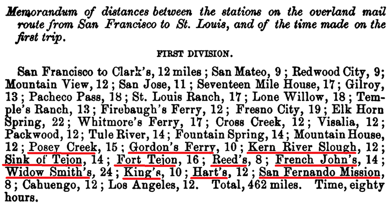
Stagecoach stations in the Santa Clarita Valley have been misidentified and poorly understood for ages. Not every stage station sat along John Butterfield's line, yet if you added up every claim to a "Butterfield Overland" station in the greater SCV, the mail never would have gotten delivered because Overland Mail Company teams would still be criss-crossing our valley. The fact is, several stage lines operated in the Santa Clarita Valley at different times, among them the Telegraph Stage Company and Remi Nadeau's freight line that ran from the Cerro Gordo mines through Soledad Canyon and on to Los Angeles. The Overland Mail didn't run through Soledad Canyon or Acton or, for that matter, Hasley Canyon. It ran along one specific north-south route through the SCV, with a station roughly every 10 to 12 miles. In this important treatise, written for SCVHistory.com for the benefit of future researchers, Gerald Ahnert, one of the foremost experts on the Butterfield Trail and the Overland Mail Company, examines newly available primary source material to pinpoint the company's stagecoach station locations along a 128-mile stretch of the route, from the San Fernando Mission on the south to Posey (aka Poso) Creek above Bakersfield on the north. While some of the stations predated and some outlived their use as Overland Mail stations — the company operated from 1858-1861 only — Ahnert identifies them by their names as they were known during the period of study and provides GPS coordinates. Listed from south to north, the 11 stations (and their current place-names) are:
Anything else was not a "Butterfield Overland" station.
About the Author.
Gerald T. Ahnert has been researching the history of the Butterfield Trail in Arizona since 1970, when an aerospace contract first took him to the Grand Canyon State. In 2011 his research culminated in the publication of his second book, "The Butterfield Trail and Overland Mail Co. in Arizona, 1858-1861." Ahnert is a member of the Arizona Historical Society, which honored him in 2011 for his efforts to preserve the trail on the Sentinel Plain in Western Arizona; and of the Southern Trails Chapter of the Oregon-California Trails Association. He has recently written about the Butterfield Trail for the association's Desert Tracks publication and for the Overland Journal. His articles have been published in the Sunday New York Times, Antiques Journal, Coin World and other hobby periodicals, and online by the California Parks Department. Before his wanderlust took hold, Ahnert had been a micro-electronic designer for the NASA-2 spaceflight simulator on the Apollo 11 project. Then, bitten by the trail bug, Ahnert and his wife spent 1973 and 1974 crossing the Sahara Desert on one of the world's longest desert trails, the Tanezrouf. For the past 35 years the couple has owned gold mining claims in the Klondike in Canada's Yukon Territory, where they make their summer home. The rest of the year they live in Syracuse, N.Y. — where Gerald studied photojournalism — except for January and February when they return to Arizona to warm up, walk the trail and lecture about the Overland Mail Co.
Download original images (Figures 1-39) here.
|